
Sary:Mayotte road map-fr.svg

Taille de cet aperçu PNG pour ce fichier SVG : 477 × 599 teboka. Habe hafa: 191 × 240 teboka | 382 × 480 teboka | 612 × 768 teboka | 815 × 1 024 teboka | 1 631 × 2 048 teboka | 1 033 × 1 297 teboka
Rakitra niaviana (rakitra SVG, habe 1 033 × 1 297 teboka, habe : 738 kio)
Ambangovangony
| Visavisa |
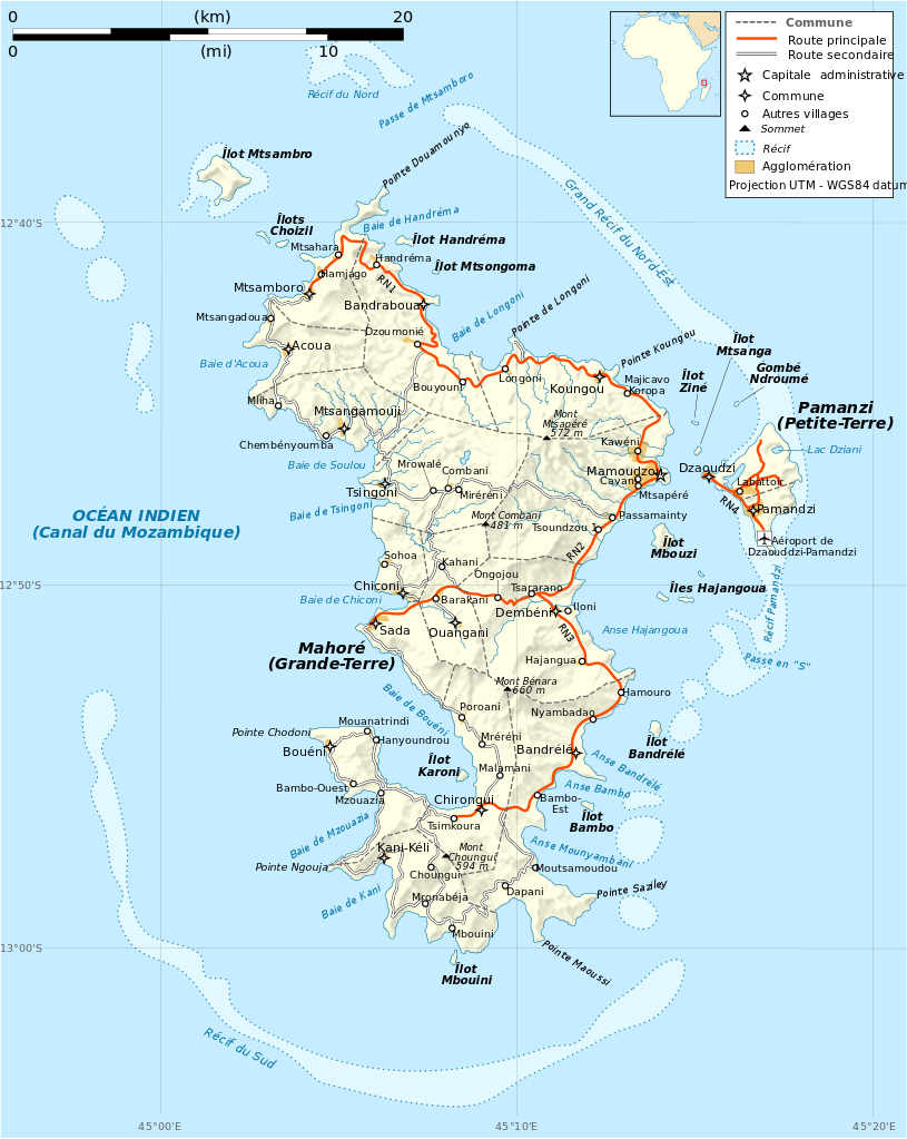
Français : Carte routière de Mayotte en français. Utiliser la version PNG dans les articles pour un rendu plus rapide.
|
| Daty | |
| Loharano |
Own work. Sources of data:
|
| Mpamorona azy | Rémi Kaupp |
| Versiona hafa |
[]
|
| SVG information |


English: This map has been created by Rémi Kaupp (User:Korrigan) and released under the license(s) stated below. You are free to use it for any purpose as long as you credit me and follow the terms of the license. You may need to credit the sources of data of the map (please check). Example:
Français : Cette carte a été créée par Rémi Kaupp (User:Korrigan) et placée sous la ou les licence(s) ci-dessous. Vous êtes libre de la réutiliser, tant que vous me citez en tant qu'auteur et suivez les instructions de la licence. Certaines sources de données de la carte doivent peut-être être créditées, veuillez vérifier. Exemple :
|
 |
Moi, en tant que détenteur des droits d’auteur sur cette œuvre, je la publie sous les licences suivantes :

|
Nomena ny alalana mandika, mizara ary/na manova ity rakitra ity araka ny GNU Free Documentation License na versiona hafa toariana natontan'i Free Software Foundation; tsy misy fizarana tsy azo ovaina, tsy misy soratra andoham-pejy na soratra am-param-pejy. Ao amin'ny fizarana mitondra anarana GNU Free Documentation License ny soratr'ity fahazoan-dalana ity. |
This file is licensed under the Creative Commons Attribution-Share Alike 4.0 International, 3.0 Unported, 2.5 Generic, 2.0 Generic and 1.0 Generic license.
- Azonao am-palalahana:
- ny mizara – ny mandika, mizara sy manome ity vokatr'asa ity
- ny mamerina – ny manova ity vokatr'asa ity
- Raha manaraka ireo fepetra ireo :
- mahalala ny namorona azy voalohany – Tsy maintsy manome fampahalalana arifomba momba ny mpamorona ianao, manome rohy manondro ny fahazoan'alalana ary raha nisy fiovana natao. Azonao atao amin'izay fomba rehetra azo atao izany zavatra izany, fa tsy amin'ny fomba milaza hoe manohana na manaiky ny fampiasanao an'ilay asa ilay mpamorona.
- zaraina mitovy – Raha manova, mamadika na mifototra amin'ity asa ity ianao dia tsy maintsy mizara ny vokany amin'ny lisansa mitovy na mifandraika amin'ny lisansan'ny asa niaviana.
Afaka mifidy iray amin'ireo lisansa ireo ianao.
Tantara ny rakitra
Tsindrio eo amin'ny daty/ora iray mba hijery ny toetra n'ilay rakitra tamin'io fotoana io.
| Daty sy ora | saritapaka | Habe | Mpikambana | resaka | |
|---|---|---|---|---|---|
| ankehitriny | 24 Martsa 2009 à 21:20 | | 1 033 × 1 297 (738 kio) | Korrigan | {{Information |Description={{en|Road map of Mayotte in French. Use the PNG version in articles for faster loading.}} {{fr|Carte routière de Mayotte en français. Utiliser [[:File:Mayotte_road_map-fr.png|la version PN |
Fampiasana an'io rakitra io
Tsy misy pejy mampiasa an'ity rakitra ity.
Fampiasan-drakitra maneran-tontolo
Mampiasa ity rakitra ity ireo wiki hafa ireo: