
Sary:Mayotte, vue par Sentinel 2 (cropped).jpg

Rakitra niaviana (4 100 × 4 381 teboka, haben'ilay rakitra : 11,67 Mio, endrika MIME : image/jpeg)
Ambangovangony
| Visavisa |
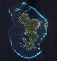
Français : L'ile de Mayotte dans l’océan indien vue par le satellite Sentinel 2, le 14 aout 2021.
English: Mayotte island (Indian Ocean) photographed by satellite Sentinel 2 on 14th August 2021. |
| Daty | |
| Loharano | https://phototheque.cnes.fr/cnes/media/68576 |
| Mpamorona azy | European Space Agency / CNES |
| Versiona hafa |
_(cropped).jpg)

.jpg)
| Lieu de la prise de vue | | Voir cet endroit et d’autres images sur : OpenStreetMap |
|---|
.jpg¶ms=-12.843056_N_0045.138333_E_globe:Earth_type:camera__&language=mg)

|
This image contains data from a satellite in the Copernicus Programme, such as Sentinel-1, Sentinel-2 or Sentinel-3. Attribution is required when using this image.
Fampatsiahivana: Contains modified Copernicus Sentinel data 2021
The use of Copernicus Sentinel Data is regulated under EU law (Commission Delegated Regulation (EU) No 1159/2013 and Regulation (EU) No 377/2014). Relevant excerpts:
Free access shall be given to GMES dedicated data [...] made available through GMES dissemination platforms [...].
Access to GMES dedicated data [...] shall be given for the purpose of the following use in so far as it is lawful:
GMES dedicated data [...] may be used worldwide without limitations in time.
GMES dedicated data and GMES service information are provided to users without any express or implied warranty, including as regards quality and suitability for any purpose. |

|
Cette image a été promue selon les critères des images de valeur, et est considérée comme l’image de plus grande valeur sur Commons dans le domaine : Mayotte island, France - satellite view.. La proposition est consultable sur Commons:Valued image candidates/Mayotte, vue par Sentinel 2 (cropped).jpg. |
.jpg)
Tantara ny rakitra
Tsindrio eo amin'ny daty/ora iray mba hijery ny toetra n'ilay rakitra tamin'io fotoana io.
| Daty sy ora | saritapaka | Habe | Mpikambana | resaka | |
|---|---|---|---|---|---|
| ankehitriny | 17 Febroary 2022 à 11:52 | | 4 100 × 4 381 (11,67 Mio) | Don-vip | File:Mayotte, vue par Sentinel 2.jpg cropped 18 % horizontally, 12 % vertically using CropTool with lossless mode. |
Fampiasana an'io rakitra io
Mampiasa ity rakitra ity io pejy io:
Fampiasan-drakitra maneran-tontolo
Mampiasa ity rakitra ity ireo wiki hafa ireo:
- Fampiasana eo amin'i ar.wikipedia.org
- Fampiasana eo amin'i arz.wikipedia.org
- Fampiasana eo amin'i ast.wikipedia.org
- Fampiasana eo amin'i az.wikipedia.org
- Fampiasana eo amin'i ca.wikipedia.org
- Fampiasana eo amin'i ceb.wikipedia.org
- Fampiasana eo amin'i ce.wikipedia.org
- Fampiasana eo amin'i cy.wikipedia.org
- Fampiasana eo amin'i de.wikivoyage.org
- Fampiasana eo amin'i eo.wikipedia.org
- Fampiasana eo amin'i es.wikipedia.org
- Fampiasana eo amin'i fr.wikipedia.org
- Fampiasana eo amin'i fr.wikinews.org
- Fampiasana eo amin'i fr.wikivoyage.org
- Fampiasana eo amin'i ga.wikipedia.org
- Fampiasana eo amin'i gl.wikipedia.org
- Fampiasana eo amin'i hy.wikipedia.org
- Fampiasana eo amin'i ig.wikipedia.org
- Fampiasana eo amin'i no.wikipedia.org
- Fampiasana eo amin'i oc.wikipedia.org
- Fampiasana eo amin'i pl.wikipedia.org
- Fampiasana eo amin'i ps.wikipedia.org
- Fampiasana eo amin'i ru.wikinews.org
- Fampiasana eo amin'i tl.wikipedia.org
- Fampiasana eo amin'i tt.wikipedia.org
- Fampiasana eo amin'i vi.wikipedia.org
- Fampiasana eo amin'i www.wikidata.org
.jpg)