
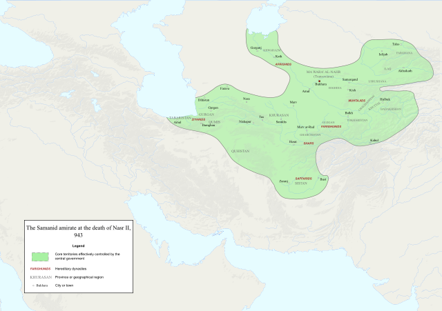
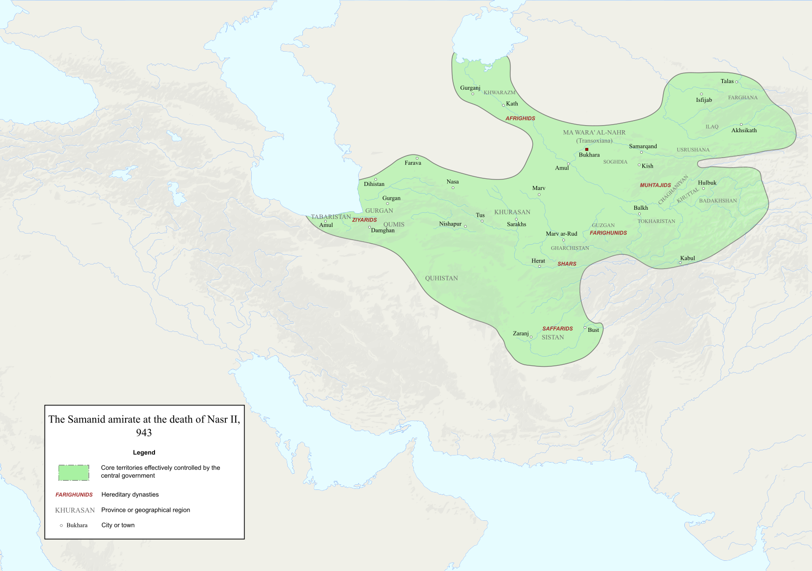
Sary:Map of the Samanid amirate at the death of Nasr II, 943.svg

Rakitra niaviana (rakitra SVG, habe 1 603 × 1 127 teboka, habe : 6,95 Mio)
Ambangovangony
| Visavisa |
English: Map of the Samanid amirate at the death of Nasr II. |
| Loharano |
Map is mainly based on two maps of mid 10th-century Central Asia under the Samanids in the pages 23 and 25 of An Historical Atlas of Central Asia, written by Yuri Bregel and published by Brill, supplied by NAṢR (I) B. AḤMAD (I) B. ESMĀʿIL [1] and Frye, R. N. (1975). "The Sāmānids". In Frye, Richard N. (ed.). The Cambridge History of Iran, Volume 4: From the Arab Invasion to the Saljuqs. Cambridge: Cambridge University Press. pp. 136–161. Since the maps in the source "only" showed Central Asia, I was missing very few parts of the southern border of the Samanids, which I used the following sources to construct;
|
| Mpamorona azy | Original file by Ro4444, edited by me |
| Alalana (Hampiasa ity rakitra ity indray) |
File:Abbasid_Caliphate_891-892.png |

|
Nomena ny alalana mandika, mizara ary/na manova ity rakitra ity araka ny GNU Free Documentation License na versiona hafa toariana natontan'i Free Software Foundation; tsy misy fizarana tsy azo ovaina, tsy misy soratra andoham-pejy na soratra am-param-pejy. Ao amin'ny fizarana mitondra anarana GNU Free Documentation License ny soratr'ity fahazoan-dalana ity. |
- Azonao am-palalahana:
- ny mizara – ny mandika, mizara sy manome ity vokatr'asa ity
- ny mamerina – ny manova ity vokatr'asa ity
- Raha manaraka ireo fepetra ireo :
- mahalala ny namorona azy voalohany – Tsy maintsy manome fampahalalana arifomba momba ny mpamorona ianao, manome rohy manondro ny fahazoan'alalana ary raha nisy fiovana natao. Azonao atao amin'izay fomba rehetra azo atao izany zavatra izany, fa tsy amin'ny fomba milaza hoe manohana na manaiky ny fampiasanao an'ilay asa ilay mpamorona.
- zaraina mitovy – Raha manova, mamadika na mifototra amin'ity asa ity ianao dia tsy maintsy mizara ny vokany amin'ny lisansa mitovy na mifandraika amin'ny lisansan'ny asa niaviana.
Tantara ny rakitra
Tsindrio eo amin'ny daty/ora iray mba hijery ny toetra n'ilay rakitra tamin'io fotoana io.
| Daty sy ora | saritapaka | Habe | Mpikambana | resaka | |
|---|---|---|---|---|---|
| ankehitriny | 3 Desambra 2022 à 14:06 | | 1 603 × 1 127 (6,95 Mio) | HistoryofIran | ditto |
| 3 Desambra 2022 à 14:02 |  | 1 603 × 1 127 (6,95 Mio) | HistoryofIran | several adjustments | |
| 3 Oktobra 2020 à 02:22 |  | 1 603 × 1 127 (6,91 Mio) | HistoryofIran | removed banijurids, didnt rule back then | |
| 3 Oktobra 2020 à 02:19 |  | 1 603 × 1 127 (6,92 Mio) | HistoryofIran | banijurids | |
| 2 Oktobra 2020 à 16:32 |  | 1 603 × 1 127 (6,92 Mio) | HistoryofIran | moved Soghdia a bit more west | |
| 2 Oktobra 2020 à 16:28 |  | 1 603 × 1 127 (6,92 Mio) | HistoryofIran | Ghur | |
| 2 Oktobra 2020 à 16:22 |  | 1 603 × 1 127 (6,92 Mio) | HistoryofIran | small fix | |
| 2 Oktobra 2020 à 15:02 |  | 1 603 × 1 127 (6,94 Mio) | HistoryofIran | under Nasr II | |
| 2 Oktobra 2020 à 13:16 |  | 1 603 × 1 127 (6,93 Mio) | HistoryofIran | added capital dot, fixed border in tabaristan | |
| 2 Oktobra 2020 à 04:23 |  | 1 603 × 1 127 (6,92 Mio) | HistoryofIran | {{subst:Upload marker added by en.wp UW}} {{Information |Description = {{en|Map of the traditional domain of the Samanids.}} |Source = Cambridge History of Iran vol 4, Iranica, etc. Might add a more detailed list in the future. |Author = Original file by Ro4444, edited by me |Permission = File:Abbasid_Caliphate_891-892.png }} |
Fampiasana an'io rakitra io
Mampiasa ity rakitra ity io pejy io:
Fampiasan-drakitra maneran-tontolo
Mampiasa ity rakitra ity ireo wiki hafa ireo:
- Fampiasana eo amin'i az.wikipedia.org
- Fampiasana eo amin'i en.wikipedia.org
- Fampiasana eo amin'i id.wikipedia.org
- Fampiasana eo amin'i it.wikipedia.org
- Fampiasana eo amin'i ky.wikipedia.org
- Fampiasana eo amin'i lt.wikipedia.org
- Fampiasana eo amin'i pl.wikipedia.org
- Fampiasana eo amin'i ps.wikipedia.org
- Fampiasana eo amin'i ru.wikipedia.org
- Fampiasana eo amin'i ta.wikipedia.org
- Fampiasana eo amin'i tr.wikipedia.org
- Fampiasana eo amin'i uz.wikipedia.org
- Fampiasana eo amin'i zh.wikipedia.org