
Sary:LanguageMap-Kikongo-Kituba.png

Haben'ny topi-maso: 800 × 529 teboka. Habe hafa: 320 × 212 teboka | 640 × 423 teboka | 1 024 × 677 teboka | 1 420 × 939 teboka
Rakitra niaviana (1 420 × 939 teboka, haben'ilay rakitra : 89 kio, endrika MIME : image/png)
Ambangovangony
| Visavisa |
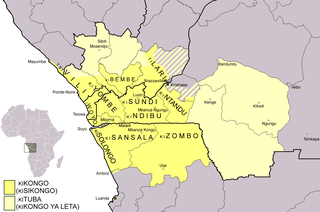
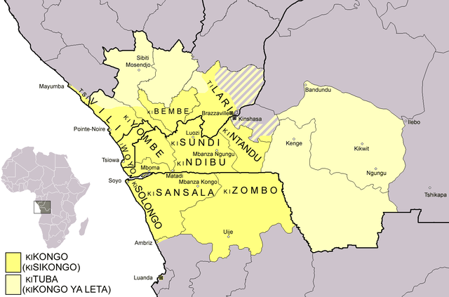
Dialect map of Kikongo. Dark yellow areas are inhabited mainly by first language speakers of the various dialects/languages of Kikongo. Names of some dialects/languages are written on the map. Pale yellow areas are inhabited by first and second language speakers of Kituba (a.k.a. Kikongo ya Leta), which is the lingua franca in the area. Kituba is understood by most speakers of Kikongo. Map drawn by Risto Kupsala. Details are based on the language maps of Ethnologue and several other sources. |
| Daty | 2 Aprily 2006 (date de téléversement originale) |
| Loharano | La source n’a pas pu être reconnue automatiquement. « Travail personnel » supposé (étant donné la revendication de droit d’auteur). |
| Mpamorona azy | L’auteur n’a pas pu être identifié automatiquement. Il est supposé qu'il s'agit de : Rasulo~commonswiki (étant donné la revendication de droit d’auteur). |
| Moi, propriétaire des droits d’auteur sur cette œuvre, la place dans le domaine public. Ceci s'applique dans le monde entier. Dans certains pays, ceci peut ne pas être possible ; dans ce cas : J’accorde à toute personne le droit d’utiliser cette œuvre dans n’importe quel but, sans aucune condition, sauf celles requises par la loi. |
Tantara ny rakitra
Tsindrio eo amin'ny daty/ora iray mba hijery ny toetra n'ilay rakitra tamin'io fotoana io.
| Daty sy ora | saritapaka | Habe | Mpikambana | resaka | |
|---|---|---|---|---|---|
| ankehitriny | 25 Febroary 2021 à 00:37 | | 1 420 × 939 (89 kio) | Somebody040404 | Reverted to version as of 10:10, 29 March 2018 (UTC) |
| 25 Febroary 2021 à 00:26 |  | 1 420 × 939 (82 kio) | Somebody040404 | ||
| 29 Martsa 2018 à 10:10 |  | 1 420 × 939 (89 kio) | Maphobbyist | South Sudan border | |
| 20 Desambra 2007 à 21:24 |  | 1 420 × 939 (60 kio) | Rasulo~commonswiki | Dialect map of Kikongo. Dark yellow areas are inhabited mainly by native speakers of the various dialects/languages of Ki(si)kongo. Names of some dialects/languages are written on the map. Pale yellow areas are inhabited by first and second language speak | |
| 22 Jolay 2006 à 12:12 |  | 718 × 518 (26 kio) | Rasulo~commonswiki | ||
| 2 Aprily 2006 à 09:49 |  | 571 × 471 (20 kio) | Rasulo~commonswiki | Dialect map of Kikongo Dark green areas are inhabited mainly by first language speakers of the various dialects/languages of Kikongo. Names of some dialects/languages are written on the map. Light green areas are inhabited by first and second language spe |
Fampiasana an'io rakitra io
Mampiasa ity rakitra ity io pejy io:
Fampiasan-drakitra maneran-tontolo
Mampiasa ity rakitra ity ireo wiki hafa ireo:
- Fampiasana eo amin'i af.wikipedia.org
- Fampiasana eo amin'i ar.wikipedia.org
- Fampiasana eo amin'i ast.wikipedia.org
- Fampiasana eo amin'i az.wiktionary.org
- Fampiasana eo amin'i bn.wikipedia.org
- Fampiasana eo amin'i ca.wikipedia.org
- Fampiasana eo amin'i cs.wikipedia.org
- Fampiasana eo amin'i da.wikipedia.org
- Fampiasana eo amin'i de.wikipedia.org
- Fampiasana eo amin'i en.wikipedia.org
- Fampiasana eo amin'i eo.wikipedia.org
- Fampiasana eo amin'i es.wikipedia.org
- Fampiasana eo amin'i eu.wikipedia.org
- Fampiasana eo amin'i fi.wikipedia.org
- Fampiasana eo amin'i frr.wikipedia.org
- Fampiasana eo amin'i fr.wikipedia.org
Hijery fampiasana eran-terikasan'ity rakitra ity.