
Sary:Dené-Yeniseian.svg

Taille de cet aperçu PNG pour ce fichier SVG : 800 × 465 teboka. Habe hafa: 320 × 186 teboka | 640 × 372 teboka | 1 024 × 595 teboka | 1 280 × 744 teboka | 2 560 × 1 489 teboka | 951 × 553 teboka
Rakitra niaviana (rakitra SVG, habe 951 × 553 teboka, habe : 608 kio)
| Visavisa |
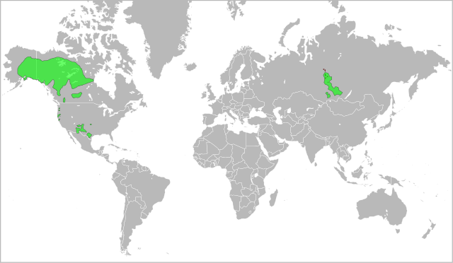
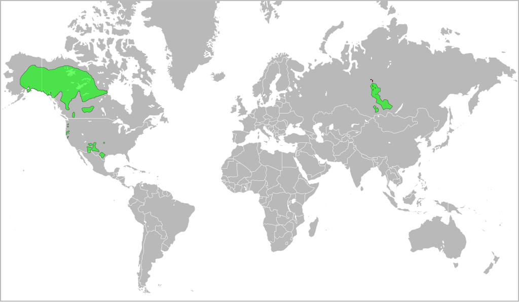
English: A map indicating the approximate distribution of the Dené-Yeniseian languages (green areas) in the XVII century. |
| Daty | (UTC) |
| Loharano | |
| Mpamorona azy |
|
Ity rakita ity dia mitondra ny fahazoan-dalana Creative Commons Attribution-Share Alike 3.0 Unported
- Azonao am-palalahana:
- ny mizara – ny mandika, mizara sy manome ity vokatr'asa ity
- ny mamerina – ny manova ity vokatr'asa ity
- Raha manaraka ireo fepetra ireo :
- mahalala ny namorona azy voalohany – Tsy maintsy manome fampahalalana arifomba momba ny mpamorona ianao, manome rohy manondro ny fahazoan'alalana ary raha nisy fiovana natao. Azonao atao amin'izay fomba rehetra azo atao izany zavatra izany, fa tsy amin'ny fomba milaza hoe manohana na manaiky ny fampiasanao an'ilay asa ilay mpamorona.
- zaraina mitovy – Raha manova, mamadika na mifototra amin'ity asa ity ianao dia tsy maintsy mizara ny vokany amin'ny lisansa mitovy na mifandraika amin'ny lisansan'ny asa niaviana.
Laogin'ny fampidirana loharano
This image is a derivative work of the following images:
- File:Yeniseian_map_XVII-XX.png licensed with Cc-by-2.5
- 2009-01-19T22:38:12Z 姫宮南 450x500 (31768 Bytes) {{Information |Description={{en|The map of distribution of [[:en:Yeniseian languages|]] (red) in the XVII century (approximate; hatching) and in the end of XX century (continuous background).}}{{ru|Карта распрос�
- File:Na-Dene_langs.png licensed with Cc-by-2.0
Téléversé avec derivativeFX
Tantara ny rakitra
Tsindrio eo amin'ny daty/ora iray mba hijery ny toetra n'ilay rakitra tamin'io fotoana io.
| Daty sy ora | saritapaka | Habe | Mpikambana | resaka | |
|---|---|---|---|---|---|
| ankehitriny | 25 Novambra 2016 à 14:17 | | 951 × 553 (608 kio) | Elevatorrailfan | No need not to include the borders of Europe. |
| 24 Mey 2010 à 16:13 |  | 951 × 553 (548 kio) | Jon Harald Søby | Fixing background issues, removing whitespace | |
| 2 Martsa 2010 à 23:59 |  | 999 × 553 (636 kio) | Ryanaxp | Made all areas green, instead of green and red, to improve clarity | |
| 2 Martsa 2010 à 23:52 |  | 999 × 553 (556 kio) | Ryanaxp | {{Information |Description={{en|A map indicating the approximate distribution of the Dené-Yeniseian languages (red and green areas) in the XVII century.}} |Source=*File:Yeniseian_map_XVII-XX.png *[[:File:Na-Dene_la |
Fampiasana an'io rakitra io
Mampiasa ity rakitra ity io pejy io:
Fampiasan-drakitra maneran-tontolo
Mampiasa ity rakitra ity ireo wiki hafa ireo:
- Fampiasana eo amin'i af.wikipedia.org
- Fampiasana eo amin'i ast.wikipedia.org
- Fampiasana eo amin'i ca.wikipedia.org
- Fampiasana eo amin'i el.wikipedia.org
- Fampiasana eo amin'i en.wikipedia.org
- Fampiasana eo amin'i es.wikipedia.org
- Fampiasana eo amin'i fi.wikipedia.org
- Fampiasana eo amin'i frr.wikipedia.org
- Fampiasana eo amin'i fr.wikipedia.org
- Fampiasana eo amin'i fy.wikipedia.org
- Fampiasana eo amin'i ja.wikipedia.org
- Fampiasana eo amin'i lez.wikipedia.org
- Fampiasana eo amin'i lt.wikipedia.org
- Fampiasana eo amin'i mrj.wikipedia.org
- Fampiasana eo amin'i nl.wikipedia.org
- Fampiasana eo amin'i no.wikipedia.org
- Fampiasana eo amin'i pl.wikipedia.org
- Fampiasana eo amin'i sr.wikipedia.org
- Fampiasana eo amin'i tr.wikipedia.org
- Fampiasana eo amin'i ur.wikipedia.org
- Fampiasana eo amin'i zh.wikipedia.org