
Sary:Corrientes-oceanicas-en.svg

Taille de cet aperçu PNG pour ce fichier SVG : 800 × 404 teboka. Habe hafa: 320 × 162 teboka | 640 × 323 teboka | 1 024 × 517 teboka | 1 280 × 647 teboka | 2 560 × 1 293 teboka | 976 × 493 teboka
Rakitra niaviana (rakitra SVG, habe 976 × 493 teboka, habe : 1,63 Mio)
Ambangovangony
| Visavisa |
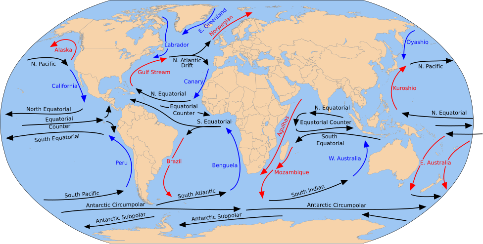
English: A detailed Robinson-projection SVG map with grouping enabled to connect all non-contiguous parts of a country's territory for easy colouring. Smaller countries can also be represented by larger circles to show their data easier. A thorough description of use and other instructions relating to can be found on the instruction page. |
| Daty | (UTC) |
| Loharano |
Ce fichier est dérivé de : Blank map of the world (Robinson projection) (10E).svg: Ce fichier est dérivé de : Corrientes-oceanicas.png: |
| Mpamorona azy |
|
_(10E).svg)

|
This SVG file contains embedded text that can be translated into your language, using any capable SVG editor, text editor or the SVG Translate tool. For more information see: About translating SVG files. |
Cette image vectorielle non W3C-spécifiée a été créée avec Inkscape .
Moi, en tant que détenteur des droits d’auteur sur cette œuvre, je la publie sous la licence suivante :
| Moi, propriétaire des droits d’auteur sur cette œuvre, la place dans le domaine public. Ceci s'applique dans le monde entier. Dans certains pays, ceci peut ne pas être possible ; dans ce cas : J’accorde à toute personne le droit d’utiliser cette œuvre dans n’importe quel but, sans aucune condition, sauf celles requises par la loi. |
Laogin'ny fampidirana loharano
This image is a derivative work of the following images:
- File:Blank map of the world (Robinson projection) (10E).svg licensed with PD-self
- 2011-05-16T04:18:31Z Milenioscuro 3100x1600 (2087786 Bytes) {{Information |Description={{en|1=A detailed Robinson-projection [[Help:SVG|SVG]] map with grouping enabled to connect all non-contiguous parts of a country's territory for easy colouring. Smaller countries can also be repres
Téléversé avec derivativeFX
Tantara ny rakitra
Tsindrio eo amin'ny daty/ora iray mba hijery ny toetra n'ilay rakitra tamin'io fotoana io.
| Daty sy ora | saritapaka | Habe | Mpikambana | resaka | |
|---|---|---|---|---|---|
| ankehitriny | 30 Jolay 2023 à 17:43 | | 976 × 493 (1,63 Mio) | Matěj Grabovský | File uploaded using svgtranslate tool (https://svgtranslate.toolforge.org/). Added translation for cs. |
| 15 Desambra 2014 à 18:08 |  | 976 × 493 (1,67 Mio) | RicHard-59 | Guls -> Gulf | |
| 28 Aprily 2014 à 14:20 |  | 976 × 493 (1,58 Mio) | Moja~commonswiki | Correct "Oyashia" -> "Oyashio" | |
| 17 Aogositra 2012 à 14:51 |  | 976 × 493 (1,66 Mio) | Popadius | Reverted to version as of 14:42, 17 August 2012 | |
| 17 Aogositra 2012 à 14:49 |  | 976 × 493 (1,1 Mio) | Popadius | small fix | |
| 17 Aogositra 2012 à 14:42 |  | 976 × 493 (1,66 Mio) | Popadius | == {{int:filedesc}} == {{Information |Description={{en|1=A detailed Robinson-projection SVG map with grouping enabled to connect all non-contiguous parts of a country's territory for easy colouring. Smaller countries can also be represente... |
Fampiasana an'io rakitra io
Mampiasa ity rakitra ity io pejy io:
Fampiasan-drakitra maneran-tontolo
Mampiasa ity rakitra ity ireo wiki hafa ireo:
- Fampiasana eo amin'i ca.wikipedia.org
- Fampiasana eo amin'i cs.wikipedia.org
- Fampiasana eo amin'i de.wikipedia.org
- Fampiasana eo amin'i en.wikipedia.org
- Fampiasana eo amin'i eo.wikipedia.org
- Fampiasana eo amin'i es.wikipedia.org
- Fampiasana eo amin'i eu.wikipedia.org
- Ozeano Australa
- Golkoko itsaslasterra
- Humboldt itsaslasterra
- Agulhasko itsaslasterra
- Alaskako itsaslasterra
- Itsaslaster Zirkunpolar Antartikoa
- Antilletako itsaslasterra
- Benguelako itsaslasterra
- Brasilgo itsaslasterra
- Kaliforniako itsaslasterra
- Kanarietako itsaslasterra
- Floridako itsaslasterra
- Azoreetako itsaslasterra
- Karibeko itsaslasterra
- Cromwell itsaslasterra
- Ekialdeko Australiako itsaslasterra
- Groenlandiako ekialdeko itsaslasterra
- Madagaskarko ekialdeko itsaslasterra
- Malvinetako itsaslasterra
- Gineako itsaslasterra
- Irminger itsaslasterra
- Kuroshio itsaslasterra
- Oyashio itsaslasterra
- Labradorko itsaslasterra
- Leeuwingo itsaslasterra
- Lomonosov itsaslasterra
- Madagaskarko itsaslasterra
- Mindanaoko itsaslasterra
- Mozambikeko itsaslasterra
- Ipar Atlantikoko itsaslasterra
- Iparraldeko itsaslaster ekuatoriala
- Kontralaster Ekuatoriala
- Ipar Pazifikoko itsaslasterra
- Norvegiako itsaslasterra
- Portugalgo itsaslasterra
Hijery fampiasana eran-terikasan'ity rakitra ity.