
Sary:Six Day War Territories 2.png
Tsy misy sary lehiba noho io.
Six_Day_War_Territories_2.png (398 × 599 teboka, haben'ilay rakitra : 52 kio, endrika MIME : image/png)
Ambangovangony

|
Une version vectorielle de cette image existe, dans le format « SVG ». Si elle n’est pas inférieure, elle devrait être utilisée à la place de la présente version pour des affichages en plus grandes dimensions ou nécessitant une meilleure résolution.
File:Six Day War Territories 2.png → File:Six Day War Terrritories.svg
Pour plus d’informations sur les images vectorielles, consultez la page de transition de Commons vers le format SVG. Voir aussi les informations à propos de la manière dont le logiciel MediaWiki gère les images au format SVG. |
 |
| Visavisa |
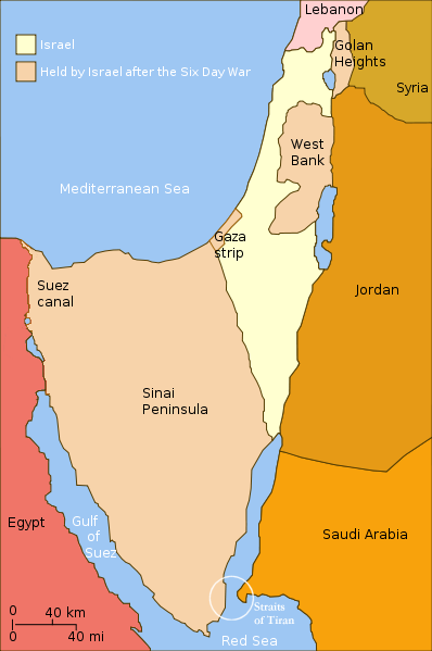
English: Israel and the territories Israel occupied in the Six day war. |
| Daty | (UTC) |
| Loharano | |
| Mpamorona azy |
|
| Versiona hafa |
[]
|


.png)


| Cette image a été retouchée, ce qui signifie qu'elle a été modifiée par ordinateur et est différente de l'image d'origine. Liste des modifications : Changed "Israeli territory before the Six day war" to "Israel", since Israels territory before the Six day war is the same as after. L'image d'origine se trouve ici : Six Day War Terrritories.png:
|
Moi, en tant que détenteur des droits d’auteur sur cette œuvre, je la publie sous la licence suivante :
Ce fichier est disponible selon les termes de la licence Creative Commons Attribution – Partage dans les Mêmes Conditions 2.5 Générique
- Azonao am-palalahana:
- ny mizara – ny mandika, mizara sy manome ity vokatr'asa ity
- ny mamerina – ny manova ity vokatr'asa ity
- Raha manaraka ireo fepetra ireo :
- mahalala ny namorona azy voalohany – Tsy maintsy manome fampahalalana arifomba momba ny mpamorona ianao, manome rohy manondro ny fahazoan'alalana ary raha nisy fiovana natao. Azonao atao amin'izay fomba rehetra azo atao izany zavatra izany, fa tsy amin'ny fomba milaza hoe manohana na manaiky ny fampiasanao an'ilay asa ilay mpamorona.
- zaraina mitovy – Raha manova, mamadika na mifototra amin'ity asa ity ianao dia tsy maintsy mizara ny vokany amin'ny lisansa mitovy na mifandraika amin'ny lisansan'ny asa niaviana.
Laogin'ny fampidirana loharano
This image is a derivative work of the following images:
- File:Six_Day_War_Terrritories.png licensed with Cc-by-sa-2.5
- 2010-11-11T21:32:04Z 99of9 398x599 (53810 Bytes) Reverted to version as of 07:04, 25 July 2010. Both POV versions should be at different locations, marked with POV and linked.
- 2010-11-08T11:06:48Z Supreme Deliciousness 398x599 (53223 Bytes) Israeli territory before the Six day war is the same as after the Six day war.
- 2010-07-25T07:04:14Z Ling.Nut 398x599 (53810 Bytes) {{Information |Description={{en|1=Israeli territories before and after the Six Day War. The Straits of Tiran are circled, between the Gulf of Aqaba, and the Red Sea.}} |Source=Yom Kippur War map.svg |Author=[[User:Ling.Nut]]
Téléversé avec derivativeFX
Tantara ny rakitra
Tsindrio eo amin'ny daty/ora iray mba hijery ny toetra n'ilay rakitra tamin'io fotoana io.
| Daty sy ora | saritapaka | Habe | Mpikambana | resaka | |
|---|---|---|---|---|---|
| ankehitriny | 12 Novambra 2010 à 12:15 | | 398 × 599 (52 kio) | Supreme Deliciousness | {{Information |Description={{en|1=Israel and the territories Israel occupied in the Six day war.</br>in yellow: Israel within the "Green Line" borders (per 1949 ceasefire agreements); in light maroon: Territories Israel seized during |
Fampiasana an'io rakitra io
Tsy misy pejy mampiasa an'ity rakitra ity.
Fampiasan-drakitra maneran-tontolo
Mampiasa ity rakitra ity ireo wiki hafa ireo:
- Fampiasana eo amin'i als.wikipedia.org
- Fampiasana eo amin'i da.wikipedia.org
- Fampiasana eo amin'i en.wikipedia.org
- Fampiasana eo amin'i fr.wikipedia.org
- Fampiasana eo amin'i gl.wikipedia.org
- Fampiasana eo amin'i ja.wikipedia.org
- Fampiasana eo amin'i my.wikipedia.org
- Fampiasana eo amin'i no.wikipedia.org
- Fampiasana eo amin'i pl.wikipedia.org
- Fampiasana eo amin'i sh.wikipedia.org
- Fampiasana eo amin'i sv.wikipedia.org
- Fampiasana eo amin'i sv.wikiversity.org
- Fampiasana eo amin'i ta.wikipedia.org