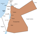
Sary:PalestineAndTransjordan.png

Le contenu de la page n’est pas pris en charge dans d’autres langues.
Avy amin'i Wikipedia

PalestineAndTransjordan.png(636 × 599 teboka, haben'ilay rakitra : 65 kio, endrika MIME : image/png)

Avy amin'i Wikimedia Commons io rakitra io ary mety ampiasain'ny tetikasa hafa. Aseho eo ambany ny famisavisana ilay rakitra.

Une version vectorielle de cette image existe, dans le format « SVG ». Si elle n’est pas inférieure, elle devrait être utilisée à la place de la présente version pour des affichages en plus grandes dimensions ou nécessitant une meilleure résolution.

File:PalestineAndTransjordan.png → File:PalestineAndTransjordan.svg

Pour plus d’informations sur les images vectorielles, consultez la page de transition de Commons vers le format SVG.
Voir aussi les informations à propos de la manière dont le logiciel MediaWiki gère les images au format SVG.

Dans les autres langues
Alemannisch  Bahasa Indonesia  Bahasa Melayu  British English  català  čeština  dansk  Deutsch  eesti  English  español  Esperanto  euskara  français  Frysk  galego  hrvatski  Ido  italiano  lietuvių  magyar  Nederlands  norsk bokmål  norsk nynorsk  occitan  Plattdüütsch  polski  português  português do Brasil  română  Scots  sicilianu  slovenčina  slovenščina  suomi  svenska  Tiếng Việt  Türkçe  vèneto  Ελληνικά  беларуская (тарашкевіца)  български  македонски  нохчийн  русский  српски / srpski  татарча/tatarça  українська  ქართული  հայերեն  বাংলা  தமிழ்  മലയാളം  ไทย  한국어  日本語  简体中文  繁體中文  עברית  العربية  فارسی  +/−
Nouvelle image SVG

Visavisa
English: Map of the British Mandate of Palestine and Transjordan.
Note: Wasserstein, Bernard (2004). Israel and Palestine: Why They Fight and Can They Stop?, pp. 105–106."Palestine, therefore, was not partitioned in 1921–1922. Transjordan was not excised but, on the contrary, added to the mandatory area. Zionism was barred from seeking to expand there – but the Balfour Declaration had never previously applied to the area east of the Jordan. Why is this important? Because the myth of Palestine's 'first partition' has become part of the concept of 'Greater Israel' and of the ideology of Jabotinsky's Revisionist movement."
Loharano

Originally uploaded on the English Wiki (all linking to en.wikipedia):

08:13, 8 June 2005 Doron (Talk / contribs) uploaded "Image:PalestineAndTransjordan.png"
Mpamorona azy User:Doron
Alalana
(Hampiasa ity rakitra ity indray)
GNU head Nomena ny alalana mandika, mizara ary/na manova ity rakitra ity araka ny GNU Free Documentation License na versiona hafa toariana natontan'i Free Software Foundation; tsy misy fizarana tsy azo ovaina, tsy misy soratra andoham-pejy na soratra am-param-pejy. Ao amin'ny fizarana mitondra anarana GNU Free Documentation License ny soratr'ity fahazoan-dalana ity.
w:fr:Creative Commons
mahalala ny namorona azy voalohany zaraina mitovy
Ity rakita ity dia mitondra ny fahazoan-dalana Creative Commons Attribution-Share Alike 3.0 Unported
Azonao am-palalahana:
  • ny mizara – ny mandika, mizara sy manome ity vokatr'asa ity
  • ny mamerina – ny manova ity vokatr'asa ity
Raha manaraka ireo fepetra ireo :
  • mahalala ny namorona azy voalohany – Tsy maintsy manome fampahalalana arifomba momba ny mpamorona ianao, manome rohy manondro ny fahazoan'alalana ary raha nisy fiovana natao. Azonao atao amin'izay fomba rehetra azo atao izany zavatra izany, fa tsy amin'ny fomba milaza hoe manohana na manaiky ny fampiasanao an'ilay asa ilay mpamorona.
  • zaraina mitovy – Raha manova, mamadika na mifototra amin'ity asa ity ianao dia tsy maintsy mizara ny vokany amin'ny lisansa mitovy na mifandraika amin'ny lisansan'ny asa niaviana.
Ce bandeau de licence a été ajouté à ce fichier dans le cadre de la procédure de mise à jour des licences des images sous GFDL.
Versiona hafa Image:BritishMandatePalestine1920.png

Légendes

Ajoutez en une ligne la description de ce que représente ce fichier

Éléments décrits dans ce fichier

dépeint Frantsay

Tantara ny rakitra

Tsindrio eo amin'ny daty/ora iray mba hijery ny toetra n'ilay rakitra tamin'io fotoana io.

Daty sy orasaritapakaHabeMpikambanaresaka
ankehitriny22 Martsa 2019 à 15:17Vignette ho an'ny 22 Martsa 2019 à 15:17636 × 599 (65 kio)Claude ZygielThis file in clearly definite as "Map of the British Mandate of Palestine '''and''' Transjordan" and used for the both territories
24 Oktobra 2017 à 12:01Vignette ho an'ny 24 Oktobra 2017 à 12:01636 × 599 (61 kio)Nicola RomaniReverted to version as of 11:02, 22 April 2016 (UTC)
30 Aogositra 2017 à 17:04Vignette ho an'ny 30 Aogositra 2017 à 17:04675 × 542 (51 kio)OnceinawhileConverted into new svg - this is the png version
19 Oktobra 2016 à 16:07Vignette ho an'ny 19 Oktobra 2016 à 16:07636 × 599 (65 kio)Claude ZygielThis file in clearly definite as "Map of the British Mandate of Palestine '''and''' Transjordan" and used for the both territories.
22 Aprily 2016 à 11:02Vignette ho an'ny 22 Aprily 2016 à 11:02636 × 599 (61 kio)Makeandtossoops
22 Aprily 2016 à 11:01Vignette ho an'ny 22 Aprily 2016 à 11:01636 × 599 (61 kio)MakeandtossRemoved Mandatory Palestine since picture is used to refer to only the emirate
4 Desambra 2011 à 15:49Vignette ho an'ny 4 Desambra 2011 à 15:49636 × 599 (66 kio)Wickey-nlthicker lining around lake
3 Desambra 2011 à 21:43Vignette ho an'ny 3 Desambra 2011 à 21:43636 × 599 (66 kio)Wickey-nlFixed border
29 Janoary 2011 à 15:29Vignette ho an'ny 29 Janoary 2011 à 15:29636 × 599 (77 kio)VadacFixed border of Transjordan within the Mandate of Palestine with Saudi Arabia per the present border having been drawn in 1965 as seen here.
24 Febroary 2006 à 11:29Vignette ho an'ny 24 Febroary 2006 à 11:29636 × 599 (89 kio)Lohen11Palestine from:

Tsy misy pejy mampiasa an'ity rakitra ity.

Fampiasan-drakitra maneran-tontolo

Mampiasa ity rakitra ity ireo wiki hafa ireo:

Hijery fampiasana eran-terikasan'ity rakitra ity.

Metadata