
Sary:Map of traditional provinces of Libye-en.svg

Taille de cet aperçu PNG pour ce fichier SVG : 625 × 599 teboka. Habe hafa: 250 × 240 teboka | 501 × 480 teboka | 801 × 768 teboka | 1 068 × 1 024 teboka | 2 136 × 2 048 teboka | 969 × 929 teboka
Rakitra niaviana (rakitra SVG, habe 969 × 929 teboka, habe : 106 kio)
| Visavisa |
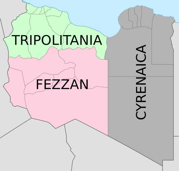
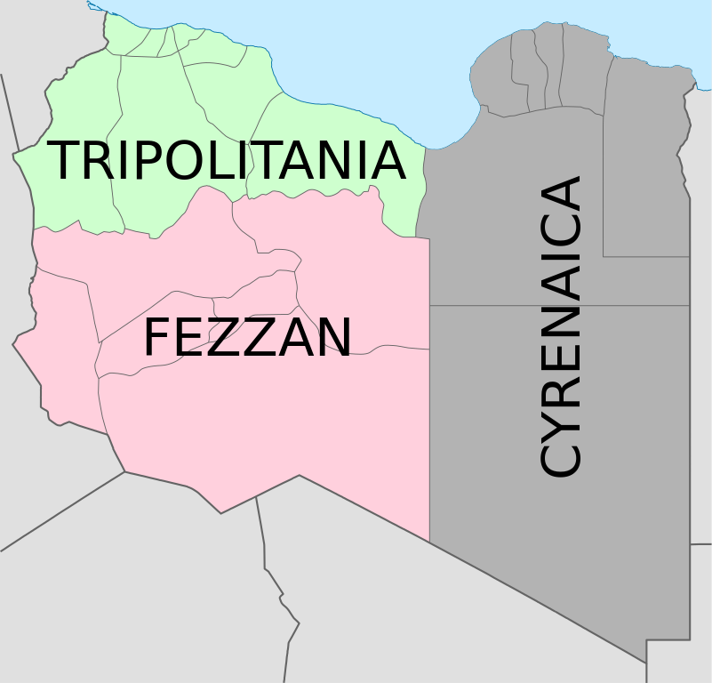
Deutsch: Historische provinzen (Governorates) Libyens English: Map of the three Governorates of Libya based on the borders of today's governorates. After independence in 1951, until 1963, Libya was divided into three governorates (muhafazat): Cyrenaica, Tripolitania, and Fezzan. The eastern border between Tripolitania and Fezzan was before 1969 slightly different: the northern part of Al Jufrah District in today's Fezzan belonged to Tripolitania, see here File:Ottoman Provinces Of Present day Libyapng.png. Español: Mapa de las tres governorates de Libia: Tripolitania, Fezzan, y Cirenaica. Français : Carte en anglais des trois provinces historiques (gouvernorats) de la Libye contemporaine. |
| Daty | (UTC) |
| Loharano | |
| Mpamorona azy |
|
| Versiona hafa |
|


| Cette image a été retouchée, ce qui signifie qu'elle a été modifiée par ordinateur et est différente de l'image d'origine. Liste des modifications : translation in english. L'image d'origine se trouve ici : Map of traditionnal provinces of Libye fr.svg:
|
Moi, en tant que détenteur des droits d’auteur sur cette œuvre, je la publie sous les licences suivantes :
Ce fichier est disponible selon les termes de la licence Creative Commons Attribution 3.0 Non transposée.
- Azonao am-palalahana:
- ny mizara – ny mandika, mizara sy manome ity vokatr'asa ity
- ny mamerina – ny manova ity vokatr'asa ity
- Raha manaraka ireo fepetra ireo :
- mahalala ny namorona azy voalohany – Tsy maintsy manome fampahalalana arifomba momba ny mpamorona ianao, manome rohy manondro ny fahazoan'alalana ary raha nisy fiovana natao. Azonao atao amin'izay fomba rehetra azo atao izany zavatra izany, fa tsy amin'ny fomba milaza hoe manohana na manaiky ny fampiasanao an'ilay asa ilay mpamorona.

|
Nomena ny alalana mandika, mizara ary/na manova ity rakitra ity araka ny GNU Free Documentation License na versiona hafa toariana natontan'i Free Software Foundation; tsy misy fizarana tsy azo ovaina, tsy misy soratra andoham-pejy na soratra am-param-pejy. Ao amin'ny fizarana mitondra anarana GNU Free Documentation License ny soratr'ity fahazoan-dalana ity. |
Afaka mifidy iray amin'ireo lisansa ireo ianao.
Laogin'ny fampidirana loharano
This image is a derivative work of the following images:
- File:Map_of_traditionnal_provinces_of_Libye_fr.svg licensed with Cc-by-3.0, GFDL
- 2011-02-25T14:34:29Z Пакко 969x929 (120204 Bytes) upg
- 2011-02-25T13:46:48Z Xfigpower 970x931 (162661 Bytes) {{Information |Description={{fr|les trois provinces mappées sur la arte actuelle de la LibyeLes couleurs sont celles symbolisées par le drapeau}} |Source=*[[:File:Libya_location_map.svg|]] |Date=2011-02-25 13:29 (UTC) |Auth
Téléversé avec derivativeFX
Tantara ny rakitra
Tsindrio eo amin'ny daty/ora iray mba hijery ny toetra n'ilay rakitra tamin'io fotoana io.
| Daty sy ora | saritapaka | Habe | Mpikambana | resaka | |
|---|---|---|---|---|---|
| ankehitriny | 24 Aogositra 2021 à 08:36 | | 969 × 929 (106 kio) | أحمد الغرباوي | File uploaded using svgtranslate tool (https://svgtranslate.toolforge.org/). Added translation for ar. |
| 6 Desambra 2020 à 15:44 |  | 969 × 929 (104 kio) | ידידיה צ' צבאן | File uploaded using svgtranslate tool (https://svgtranslate.toolforge.org/). Added translation for he. | |
| 12 Oktobra 2011 à 03:46 |  | 969 × 929 (104 kio) | Spesh531 | updated to current internal boundaries | |
| 30 Aogositra 2011 à 12:50 |  | 969 × 929 (147 kio) | Orange Tuesday | see http://www.crwflags.com/fotw/flags/ly_1951.html for source on traditional colours | |
| 30 Aogositra 2011 à 01:40 |  | 969 × 929 (124 kio) | Hellerick | Found no information on "traditional association" | |
| 13 Jiona 2011 à 20:24 |  | 969 × 929 (147 kio) | Kmusser | shift colors to match traditional association | |
| 29 Aprily 2011 à 11:04 |  | 969 × 929 (125 kio) | Hellerick | Neutral colors; + foreign nations borders | |
| 16 Martsa 2011 à 13:02 |  | 969 × 929 (121 kio) | Bourrichon | typo | |
| 16 Martsa 2011 à 13:01 |  | 969 × 929 (121 kio) | Bourrichon | +bug typo | |
| 16 Martsa 2011 à 12:58 |  | 969 × 929 (112 kio) | Bourrichon | {{Information |Description={{de|Historische provinzen (Governorates) Libyens}} {{en| Map of the three '''{{w|Governorates of Libya}}'''. After independence in 1951, until 1963, Libya was divided into three governorates (''{{w|muhafazat}}''): '''{{w|Cyrena |
Fampiasana an'io rakitra io
Mampiasa ity rakitra ity io pejy io:
Fampiasan-drakitra maneran-tontolo
Mampiasa ity rakitra ity ireo wiki hafa ireo:
- Fampiasana eo amin'i ast.wikipedia.org
- Fampiasana eo amin'i az.wikipedia.org
- Fampiasana eo amin'i bs.wikipedia.org
- Fampiasana eo amin'i ca.wikipedia.org
- Fampiasana eo amin'i cs.wikipedia.org
- Fampiasana eo amin'i diq.wikipedia.org
- Fampiasana eo amin'i en.wikipedia.org
- History of Libya
- Libya
- Geography of Libya
- Demographics of Libya
- Politics of Libya
- Economy of Libya
- Mass media in Libya
- Transport in Libya
- Armed Forces of the Libyan Arab Jamahiriya
- Foreign relations of Libya under Muammar Gaddafi
- Fatimid Caliphate
- Idris of Libya
- List of cities in Libya
- Operation Sonnenblume
- Libyan dinar
- List of heads of state of Libya
- Districts of Libya
- Great Man-Made River
- List of colonial governors of Italian Cyrenaica
- List of heads of government of Libya
- Music of Libya
- Elections in Libya
- Karamanli dynasty
- Ahmed Karamanli
- Culture of Libya
- Central Bank of Libya
- Public Scout and Girl Guide Movement
- General People's Congress (Libya)
- Human rights in Libya
- Subdivisions of Libya
- Provinces of Libya
- Islamic Tripolitania and Cyrenaica
- Ottoman Tripolitania
- Italian colonization of Libya
- History of Libya under Muammar Gaddafi
- Chadian–Libyan War
- Ancient Libya
- Template:Libya topics
- Media of Libya
- Kingdom of Libya
- Minister of Foreign Affairs (Libya)
Hijery fampiasana eran-terikasan'ity rakitra ity.