Aller au contenu

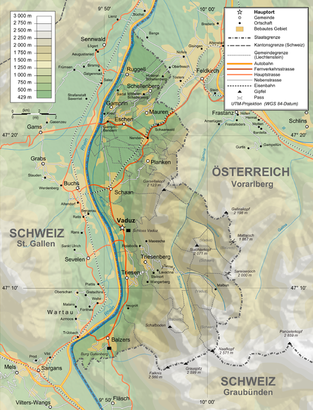
Sary:Liechtenstein topographic map-de Version Tschubby.png

Le contenu de la page n’est pas pris en charge dans d’autres langues.
Avy amin'i Wikipedia

Rakitra niaviana (2 189 × 2 862 teboka, haben'ilay rakitra : 2,2 Mio, endrika MIME : image/png)

Avy amin'i Wikimedia Commons io rakitra io ary mety ampiasain'ny tetikasa hafa. Aseho eo ambany ny famisavisana ilay rakitra.

Ambangovangony

Visavisa
Deutsch: Topographische Karte von Liechtenstein, deutsche Version
English: Topographic map in German of Liechtenstein
Français : Carte topographique en allemand du Liechtenstein
Daty
Loharano
English: Own work ;
Topographic data from the NASA Shuttle Radar Topography Mission (SRTM3 v.2) (public domain) edited with 3DEM and dlgv32 Pro, and vectorized with Inkscape ; UTM projection ; WGS84 datum ; shaded relief (N-W lightning positions) edited with The Gimp ;
Reference used for the additional data :
* Rivers, cities, railroads, routes, bathymetry : Demis add-on for World Wind (see the approval e-mail and the Demis forum) ;
* Borders and coast : World data bank II + + File:Liechtenstein-admin.png by user:Aotearoa ;
Approximate scale of topographic data : 1:1,463,000 ;
Note : The shaded relief is a raster image embedded in the SVG file.

Français : Création personnelle ;
Données topographiques de la NASA Shuttle Radar Topography Mission (SRTM3 v.2) (domaine public) éditées avec 3DEM etdlgv32 Pro, et vectorisées avec Inkscape ; projection UTM ; WGS84 datum ; relief ombré (éclairage du N-O) édité avec The Gimp ;
Références utilisées pour les données complémentaires :
* Rivières, villes, chemins de fers, routes, bathymétrie : Demis add-on for World Wind (cf. l'e-mail d'approbation de Demis et le Demis forum) ;
* Frontières et côtes : World data bank II + File:Liechtenstein-admin.png de user:Aotearoa ;
Échelle approximative des données topographiques : 1:1 463 000 ;
Note : Le relief ombré est une image bitmap embarquée dans le fichier SVG.

Approximate geographic limits of the map (30" close) :
* SW corner : 47°02'05"N – 9°40'00"E
* SE corner : 47°02'05"N – 9°70'00"E
* NE corner : 47°27'55"N – 9°70'00"E
* NW corner : 47°27'55"N – 9°40'00"E
Mpamorona azy Bourrichon, translated by NordNordWest, new Design by Tschubby
Alalana
(Hampiasa ity rakitra ity indray)
GFDL / Attribution and Share-Alike required
Versiona hafa


Moi, en tant que détenteur des droits d’auteur sur cette œuvre, je la publie sous les licences suivantes :
GNU head Nomena ny alalana mandika, mizara ary/na manova ity rakitra ity araka ny GNU Free Documentation License na versiona hafa toariana natontan'i Free Software Foundation; tsy misy fizarana tsy azo ovaina, tsy misy soratra andoham-pejy na soratra am-param-pejy. Ao amin'ny fizarana mitondra anarana GNU Free Documentation License ny soratr'ity fahazoan-dalana ity.
w:fr:Creative Commons
mahalala ny namorona azy voalohany zaraina mitovy
This file is licensed under the Creative Commons Attribution-Share Alike 4.0 International, 3.0 Unported, 2.5 Generic, 2.0 Generic and 1.0 Generic license.
Azonao am-palalahana:
  • ny mizara – ny mandika, mizara sy manome ity vokatr'asa ity
  • ny mamerina – ny manova ity vokatr'asa ity
Raha manaraka ireo fepetra ireo :
  • mahalala ny namorona azy voalohany – Tsy maintsy manome fampahalalana arifomba momba ny mpamorona ianao, manome rohy manondro ny fahazoan'alalana ary raha nisy fiovana natao. Azonao atao amin'izay fomba rehetra azo atao izany zavatra izany, fa tsy amin'ny fomba milaza hoe manohana na manaiky ny fampiasanao an'ilay asa ilay mpamorona.
  • zaraina mitovy – Raha manova, mamadika na mifototra amin'ity asa ity ianao dia tsy maintsy mizara ny vokany amin'ny lisansa mitovy na mifandraika amin'ny lisansan'ny asa niaviana.
Afaka mifidy iray amin'ireo lisansa ireo ianao.

Légendes

Ajoutez en une ligne la description de ce que représente ce fichier

Éléments décrits dans ce fichier

dépeint Frantsay

21 Jolay 2009

Tantara ny rakitra

Tsindrio eo amin'ny daty/ora iray mba hijery ny toetra n'ilay rakitra tamin'io fotoana io.

Daty sy orasaritapakaHabeMpikambanaresaka
ankehitriny3 Febroary 2016 à 14:05Vignette ho an'ny 3 Febroary 2016 à 14:052 189 × 2 862 (2,2 Mio)RokerHROoptipng -o7 -zm1-9 -i0 → 48.70% decrease
12 Febroary 2012 à 11:37Vignette ho an'ny 12 Febroary 2012 à 11:372 189 × 2 862 (4,3 Mio)Tschubby{{Information |Description= |Source= |Date= |Author= |Permission= |other_versions= }}
12 Febroary 2012 à 11:31Vignette ho an'ny 12 Febroary 2012 à 11:312 189 × 2 862 (8,6 Mio)Tschubby{{Information |Description= |Source= |Date= |Author= |Permission= |other_versions= }}
26 Janoary 2012 à 16:17Vignette ho an'ny 26 Janoary 2012 à 16:171 305 × 1 683 (2,3 Mio)Tschubby{{Information |Description= |Source= |Date= |Author= |Permission= |other_versions= }}
26 Janoary 2012 à 16:13Vignette ho an'ny 26 Janoary 2012 à 16:13794 × 1 024 (1,26 Mio)Tschubby{{Information |Description= |Source= |Date= |Author= |Permission= |other_versions= }}
21 Jolay 2009 à 09:05Vignette ho an'ny 21 Jolay 2009 à 09:051 305 × 1 683 (1,46 Mio)Tschubby{{Information |Description= |Source= |Date= |Author= |Permission= |other_versions= }}
21 Jolay 2009 à 08:50Vignette ho an'ny 21 Jolay 2009 à 08:501 338 × 1 683 (1,48 Mio)Tschubby== Summary == {{Information |Description={{de|Topographische Karte von Liechtenstein, deutsche Version}}{{en|Topographic map in German of Liechtenstein}}{{fr|Carte topographique en allemand du [[:fr:Liechtenstei

Mampiasa ity rakitra ity io pejy io:

Fampiasan-drakitra maneran-tontolo

Mampiasa ity rakitra ity ireo wiki hafa ireo:

Metadata