Sary:Byzantine Constantinople-en.png

Le contenu de la page n’est pas pris en charge dans d’autres langues.
Avy amin'i Wikipedia

Rakitra niaviana(3 200 × 2 888 teboka, haben'ilay rakitra : 2,35 Mio, endrika MIME : image/png)

Avy amin'i Wikimedia Commons io rakitra io ary mety ampiasain'ny tetikasa hafa. Aseho eo ambany ny famisavisana ilay rakitra.

Wikipedia

 Ceci est une image remarquable sur la Wikipédia en anglais (Featured pictures) et est considéré(e) comme l'une de nos meilleures images.

Si vous pensez que ce fichier doit être une Image remarquable de
Wikimedia Commons
, vous pouvez le proposer.

Si vous avez une image de qualité similaire qui peut être publiée sous une licence compatible, vous pouvez l’importer, y apposer le bandeau de licence adéquat, et la proposer.

Ambangovangony

Visavisa
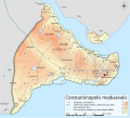
English: Topographical map of Constantinople during the Byzantine period.
Български: Топографска карта на Константинопол (Цариград) през византийския период. Източник: R. Janin, Constantinople Byzantine. Developpement urbain et repertoire topographique. Пътната мрежа и някои други детайли се основават на Dumbarton Oaks Papers 54 и други публикувани източници.
Deutsch: Topografische Karte Konstantinopels während des byzantinischen Zeitraums. Quelle: R. Janin, Constantinople Byzantine. Developpement urbain et repertoire topographique. Straßennetz und andere Einzelheiten basiert auf Dumbarton Oaks Papers 54. Kirchen, insb. nicht identifizierte und ausgegrabene Bauten sind aus dem The Byzantine Churches of Istanbul entnommen. Andere herausgegebenen Quellen wurden behilfsmäßig gebraucht.
Ελληνικά: Τοπογραφικός χάρτης Κωνσταντινουπόλεως κατά τη Βυζαντινή περίοδο. Βασική πηγή χάρτη: R. Janin, Constantinople Byzantine. Developpement urbain et repertoire topographique. Το οδικό δίκτυο και διάφορες άλλες λεπτομέρειες με βάση το Dumbarton Oaks Papers 54. Πληροφορίες για τις εκκλησίες, ιδιαίτερα τις μη ταυτοποιημένες, από την ιστοσελίδα The Byzantine Churches of Istanbul του Πανεπιστημίου της Νέας Υόρκης.
Although I've striven to make this map as complete and correct as possible, there may be some errors or omissions. Any corrections & suggestions are welcome.
Daty
Loharano

Travail personnel avec:

Mpamorona azy Cplakidas
Alalana
(Hampiasa ity rakitra ity indray)
Moi, en tant que détenteur des droits d’auteur sur cette œuvre, je la publie sous les licences suivantes :
w:fr:Creative Commons
mahalala ny namorona azy voalohany zaraina mitovy
Ity rakita ity dia mitondra ny fahazoan-dalana Creative Commons Attribution-Share Alike 3.0 Unported
Azonao am-palalahana:
  • ny mizara – ny mandika, mizara sy manome ity vokatr'asa ity
  • ny mamerina – ny manova ity vokatr'asa ity
Raha manaraka ireo fepetra ireo :
  • mahalala ny namorona azy voalohany – Tsy maintsy manome fampahalalana arifomba momba ny mpamorona ianao, manome rohy manondro ny fahazoan'alalana ary raha nisy fiovana natao. Azonao atao amin'izay fomba rehetra azo atao izany zavatra izany, fa tsy amin'ny fomba milaza hoe manohana na manaiky ny fampiasanao an'ilay asa ilay mpamorona.
  • zaraina mitovy – Raha manova, mamadika na mifototra amin'ity asa ity ianao dia tsy maintsy mizara ny vokany amin'ny lisansa mitovy na mifandraika amin'ny lisansan'ny asa niaviana.
GNU head Nomena ny alalana mandika, mizara ary/na manova ity rakitra ity araka ny GNU Free Documentation License na versiona hafa toariana natontan'i Free Software Foundation; tsy misy fizarana tsy azo ovaina, tsy misy soratra andoham-pejy na soratra am-param-pejy. Ao amin'ny fizarana mitondra anarana GNU Free Documentation License ny soratr'ity fahazoan-dalana ity.
Afaka mifidy iray amin'ireo lisansa ireo ianao.
Versiona hafa

[ovaina]

Full maps

SVG:

PNG:

Numeric versions

Regions

Roads

Open this image as an overlay in Google Earth (Google Maps, Bing) (Help|Source)

Légendes

Ajoutez en une ligne la description de ce que représente ce fichier
Constantinople during the Byzantine period

Éléments décrits dans ce fichier

dépeint Frantsay

Valeur sans élément de Wikidata

28 Oktobra 2008

type MIME Frantsay

image/png

b4b5347456038e42cfa57b6c9763eaefb8d38a55

méthode de détermination Frantsay : SHA-1 Frantsay

2 462 235 octet

hauteur Frantsay

2 888 pixel

largeur Frantsay

3 200 pixel

Tantara ny rakitra

Tsindrio eo amin'ny daty/ora iray mba hijery ny toetra n'ilay rakitra tamin'io fotoana io.

Daty sy orasaritapakaHabeMpikambanaresaka
ankehitriny25 Aprily 2010 à 17:42Vignette ho an'ny 25 Aprily 2010 à 17:423 200 × 2 888 (2,35 Mio)MahahahaneapneapCompressed
15 Desambra 2009 à 12:56Vignette ho an'ny 15 Desambra 2009 à 12:563 200 × 2 888 (3,42 Mio)Cplakidaslarger & more detailed version, various corrections, Galata included
30 Jiona 2009 à 23:08Vignette ho an'ny 30 Jiona 2009 à 23:082 134 × 2 000 (1,62 Mio)FalcorianLossless compression with pngout.
8 Janoary 2009 à 22:47Vignette ho an'ny 8 Janoary 2009 à 22:472 134 × 2 000 (1,84 Mio)Cplakidasmore info, minor tweaks & corrections
28 Oktobra 2008 à 11:48Vignette ho an'ny 28 Oktobra 2008 à 11:482 134 × 2 000 (1,76 Mio)Cplakidas{{Information |Description={{en|1=Topographical map of Constantinople during the Byzantine period. Map source: R. Janin, ''Constantinople Byzantine. Developpement urbain et repertoire topographique''. Road network and some other d

Mampiasa ity rakitra ity io pejy io:

Fampiasan-drakitra maneran-tontolo

Mampiasa ity rakitra ity ireo wiki hafa ireo:

Hijery fampiasana eran-terikasan'ity rakitra ity.

Metadata