
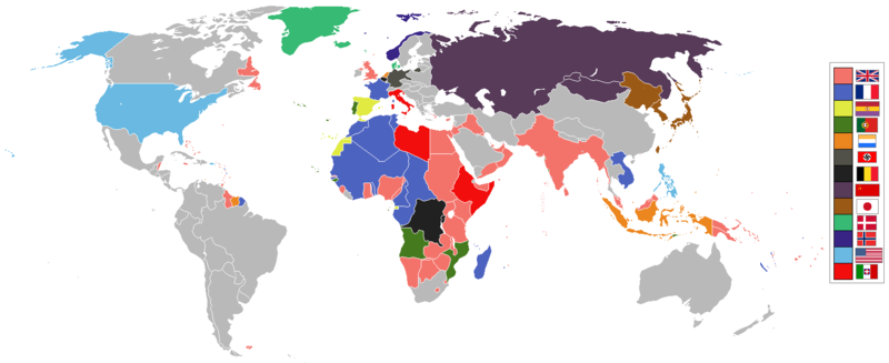
Sary:World 1936 empires colonies territory.png

Rakitra niaviana (1 527 × 624 teboka, haben'ilay rakitra : 44 kio, endrika MIME : image/png)
1936 coolio stuff
Ambangovangony
العربية
English
മലയാളം
Deutsch
한국어
Українська
简体中文
繁體中文

|
Cette image (de type historical map) devrait être recréée dans un format vectoriel, en tant que fichier SVG. Cela offrirait plusieurs avantages : voir Commons:Media for cleanup pour plus d'informations. Si une version SVG de cette image est déjà disponible, merci de bien vouloir l'envoyer. Après cela, remplacez ce modèle par {{vector version available|nouveau nom d'image.svg}}.
|

|
Avertissement juridique Ce fichier montre ou ressemble à un symbole qui a été utilisé par le gouvernement communiste de l’Union soviétique, les gouvernements communistes d’autres pays en Europe, des organisations associés à eux ou des partis interdits dans leurs pays respectifs. L’utilisation de ce symbole peut être illégale en Hongrie, Lituanie, Lettonie, Ukraine et Pologne, selon le contexte. En Hongrie, la loi applicable est le Code pénal hongrois 269/B.§ (1993). |

|
Avertissement Cette image montre (ou ressemble à) un symbole qui fut (ou est) utilisé par le national-socialisme ou d'autres organisations anticonstitutionnelles. L'usage de ce symbole est restreint par la législation allemande. Utiliser des images d'organisations interdites en Allemagne (comme la svastika du parti nazi) peut, selon le contexte être illégal en Allemagne. Une législation similaire est appliquée en Autriche, Hongrie, Pologne, République tchèque, France, Brésil, Russie et d'autres pays. La loi applicable en Allemagne est le Paragraphe 86a du Code criminel allemand (StGB), et en France l'article R645-1 du Code pénal. |
See also
| Maps of world history | |
| BC | |
|
| |
| AD |
1 · 50 · 100 · 200 · 250 · 300 · 400 · 500 · 700 · 750 · 820 · 900 · 1200 · 1500 · 1556 · 1648 · 1700 · 1750 · 1815 · 1859 · 1871 · 1914 · 1935 · 1954 · 1989 · 2000 · |
|
Maps of colonization history | |
|
see also: Eastern Hemisphere only maps template (1300BC-1500AD) | |
| (this template: · view · discuss ) | |
.jpg)
._LOC_2001620596.jpg)

|
Nomena ny alalana mandika, mizara ary/na manova ity rakitra ity araka ny GNU Free Documentation License na versiona hafa toariana natontan'i Free Software Foundation; tsy misy fizarana tsy azo ovaina, tsy misy soratra andoham-pejy na soratra am-param-pejy. Ao amin'ny fizarana mitondra anarana GNU Free Documentation License ny soratr'ity fahazoan-dalana ity. |
| Ity rakita ity dia mitondra ny fahazoan-dalana Creative Commons Attribution-Share Alike 3.0 Unported | ||
| ||
| Ce bandeau de licence a été ajouté à ce fichier dans le cadre de la procédure de mise à jour des licences des images sous GFDL. |
Tantara ny rakitra
Tsindrio eo amin'ny daty/ora iray mba hijery ny toetra n'ilay rakitra tamin'io fotoana io.
| Daty sy ora | saritapaka | Habe | Mpikambana | resaka | |
|---|---|---|---|---|---|
| ankehitriny | 6 Mey 2020 à 13:41 | 1 527 × 624 (44 kio) | The- | The Dominions should not be shaded in British Empire colour post-1931 Statute of Westmisnter. They had independent foreign policies and were no longer under British control in any way, shape or form. | |
| 12 Mey 2019 à 12:34 | 1 527 × 624 (44 kio) | The- | If there are some problems with the accurate map, fix the accurate map, don't revert back to the old inaccurate map! | ||
| 12 Septambra 2018 à 07:34 |  | 1 458 × 627 (33 kio) | Oleksiy.golubov | Reverted to version as of 13:34, 29 July 2012 (UTC): no reason to indicate Turkey and China; colors of Belgium and the Netherlands were wrong. | |
| 20 Jolay 2018 à 19:51 | 1 527 × 624 (3,64 Mio) | SuperSucker | oops forgot Germany had Nazi flag in 1936 | ||
| 20 Jolay 2018 à 19:39 | 1 527 × 624 (3,64 Mio) | SuperSucker | fix - added Turkey (it existed as Turkey in 1936) and China; changed China's flag as they had it changed by 1930 | ||
| 20 Aogositra 2016 à 14:47 | 1 527 × 624 (44 kio) | The- | Some fixes | ||
| 17 Aprily 2016 à 20:29 | 1 527 × 624 (44 kio) | The- | More accurate map | ||
| 29 Jolay 2012 à 13:34 |  | 1 458 × 627 (33 kio) | Faunas | Reverted to version as of 13:31, 29 July 2012 | |
| 29 Jolay 2012 à 13:33 |  | 1 458 × 627 (33 kio) | Faunas | In the previous version, São Tomé e Príncipe was indicated as a Spanish colony; I changed it to indicate it was a Portuguese colony (which it was). | |
| 29 Jolay 2012 à 13:31 |  | 1 458 × 627 (33 kio) | Faunas | In the previous version, São Tomé e Príncipe was indicated as a Spanish colony; I changed it to indicate it was a Portuguese colony (which it was). |
Fampiasana an'io rakitra io
Mampiasa ity rakitra ity io pejy io:
Fampiasan-drakitra maneran-tontolo
Mampiasa ity rakitra ity ireo wiki hafa ireo:
- Fampiasana eo amin'i af.wikipedia.org
- Fampiasana eo amin'i am.wikipedia.org
- Fampiasana eo amin'i ar.wikipedia.org
- Fampiasana eo amin'i arz.wikipedia.org
- Fampiasana eo amin'i az.wikipedia.org
- Fampiasana eo amin'i bn.wikipedia.org
- Fampiasana eo amin'i bs.wikipedia.org
- Fampiasana eo amin'i de.wikipedia.org
- Fampiasana eo amin'i en.wikipedia.org
- Fampiasana eo amin'i fa.wikipedia.org
- Fampiasana eo amin'i fr.wikipedia.org
- Fampiasana eo amin'i ja.wikipedia.org
- Fampiasana eo amin'i li.wikipedia.org
- Fampiasana eo amin'i lv.wikipedia.org
- Fampiasana eo amin'i ms.wikipedia.org
- Fampiasana eo amin'i nl.wikipedia.org
- Fampiasana eo amin'i pt.wikipedia.org
- Fampiasana eo amin'i sr.wikipedia.org
- Fampiasana eo amin'i th.wikipedia.org
- Fampiasana eo amin'i uk.wikipedia.org
- Fampiasana eo amin'i www.wikidata.org