
Sary:Shimla Southern Side of Ridge.JPG
Haben'ny topi-maso: 800 × 560 teboka. Habe hafa: 320 × 224 teboka | 640 × 448 teboka | 1 024 × 716 teboka | 1 280 × 895 teboka | 2 560 × 1 791 teboka | 3 424 × 2 395 teboka
Rakitra niaviana (3 424 × 2 395 teboka, haben'ilay rakitra : 4,18 Mio, endrika MIME : image/jpeg)
Ambangovangony
| Visavisa |
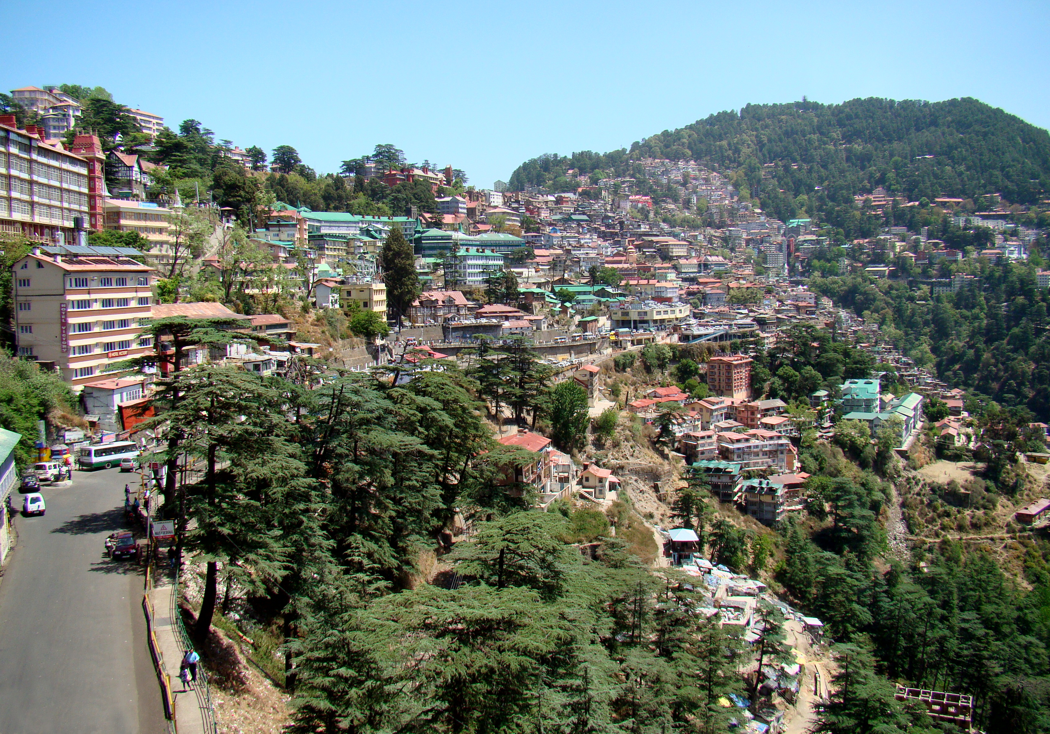
English: The centre of Shimla seen from near the railway station. This part of the city is on the southern side of the ridge. The road starting in the bottom left of the photo goes to the bus terminal just to the right of the center of the photo. Behind it the old town begins, with really steep streets and alleys, continuing up to the ridge, where no cars are allowed. |
| Daty | |
| Loharano | Own work by uploader, http://bjornfree.com/galleries.html |
| Mpamorona azy | Bjørn Christian Tørrissen |
| Lieu de la prise de vue | | Voir cet endroit et d’autres images sur : OpenStreetMap |
|---|
Moi, en tant que détenteur des droits d’auteur sur cette œuvre, je la publie sous les licences suivantes :
Ity rakita ity dia mitondra ny fahazoan-dalana Creative Commons Attribution-Share Alike 3.0 Unported
- Azonao am-palalahana:
- ny mizara – ny mandika, mizara sy manome ity vokatr'asa ity
- ny mamerina – ny manova ity vokatr'asa ity
- Raha manaraka ireo fepetra ireo :
- mahalala ny namorona azy voalohany – Tsy maintsy manome fampahalalana arifomba momba ny mpamorona ianao, manome rohy manondro ny fahazoan'alalana ary raha nisy fiovana natao. Azonao atao amin'izay fomba rehetra azo atao izany zavatra izany, fa tsy amin'ny fomba milaza hoe manohana na manaiky ny fampiasanao an'ilay asa ilay mpamorona.
- zaraina mitovy – Raha manova, mamadika na mifototra amin'ity asa ity ianao dia tsy maintsy mizara ny vokany amin'ny lisansa mitovy na mifandraika amin'ny lisansan'ny asa niaviana.

|
Nomena ny alalana mandika, mizara ary/na manova ity rakitra ity araka ny GNU Free Documentation License na versiona hafa toariana natontan'i Free Software Foundation; tsy misy fizarana tsy azo ovaina, tsy misy soratra andoham-pejy na soratra am-param-pejy. Ao amin'ny fizarana mitondra anarana GNU Free Documentation License ny soratr'ity fahazoan-dalana ity. |
Afaka mifidy iray amin'ireo lisansa ireo ianao.
Tantara ny rakitra
Tsindrio eo amin'ny daty/ora iray mba hijery ny toetra n'ilay rakitra tamin'io fotoana io.
| Daty sy ora | saritapaka | Habe | Mpikambana | resaka | |
|---|---|---|---|---|---|
| ankehitriny | 19 Aogositra 2010 à 19:07 | | 3 424 × 2 395 (4,18 Mio) | Uspn | {{Information |Description={{en|1=The centre of Shimla seen from near the railway station. This part of the city is on the southern side of the ridge. The road starting in the bottom left of the photo goes to the bus terminal just to the right of the cent |
Fampiasana an'io rakitra io
Mampiasa ity rakitra ity io pejy io:
Fampiasan-drakitra maneran-tontolo
Mampiasa ity rakitra ity ireo wiki hafa ireo:
- Fampiasana eo amin'i ar.wikipedia.org
- Fampiasana eo amin'i arz.wikipedia.org
- Fampiasana eo amin'i az.wikipedia.org
- Fampiasana eo amin'i bg.wikipedia.org
- Fampiasana eo amin'i bh.wikipedia.org
- Fampiasana eo amin'i bn.wikipedia.org
- Fampiasana eo amin'i ca.wikipedia.org
- Fampiasana eo amin'i ceb.wikipedia.org
- Fampiasana eo amin'i ce.wikipedia.org
- Fampiasana eo amin'i cs.wikipedia.org
- Fampiasana eo amin'i de.wikivoyage.org
- Fampiasana eo amin'i en.wikipedia.org
- Fampiasana eo amin'i en.wikivoyage.org
- Fampiasana eo amin'i eo.wikipedia.org
- Fampiasana eo amin'i eu.wikipedia.org
- Fampiasana eo amin'i fa.wikipedia.org
- Fampiasana eo amin'i frr.wikipedia.org
- Fampiasana eo amin'i fr.wikipedia.org
- Fampiasana eo amin'i fr.wikivoyage.org
- Fampiasana eo amin'i he.wikivoyage.org
- Fampiasana eo amin'i hu.wikipedia.org
- Fampiasana eo amin'i hy.wikipedia.org
- Fampiasana eo amin'i it.wikivoyage.org
- Fampiasana eo amin'i ka.wikipedia.org
- Fampiasana eo amin'i kn.wikipedia.org
- Fampiasana eo amin'i lld.wikipedia.org
- Fampiasana eo amin'i lv.wikipedia.org
- Fampiasana eo amin'i no.wikipedia.org
- Fampiasana eo amin'i or.wikipedia.org
- Fampiasana eo amin'i pl.wiktionary.org
- Fampiasana eo amin'i sa.wikipedia.org
- Fampiasana eo amin'i simple.wikipedia.org
- Fampiasana eo amin'i sr.wikipedia.org
- Fampiasana eo amin'i tg.wikipedia.org
- Fampiasana eo amin'i tt.wikipedia.org
- Fampiasana eo amin'i uk.wikipedia.org
- Fampiasana eo amin'i ur.wikipedia.org
- Fampiasana eo amin'i www.wikidata.org
Hijery fampiasana eran-terikasan'ity rakitra ity.