
Sary:Kingdoms around Israel 830 map.svg

Taille de cet aperçu PNG pour ce fichier SVG : 502 × 599 teboka. Habe hafa: 201 × 240 teboka | 402 × 480 teboka | 644 × 768 teboka | 858 × 1 024 teboka | 1 717 × 2 048 teboka | 720 × 859 teboka
Rakitra niaviana (rakitra SVG, habe 720 × 859 teboka, habe : 122 kio)
| Visavisa |
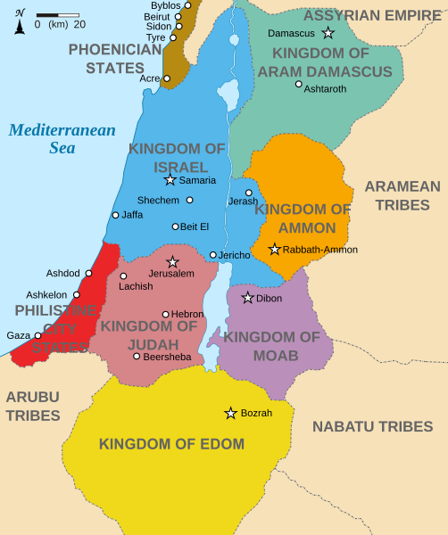
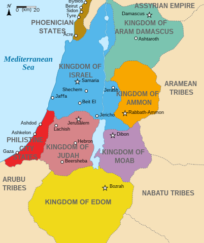
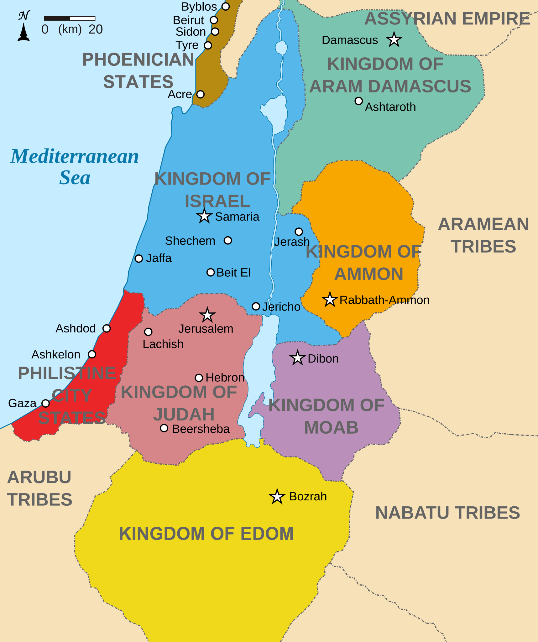
English: Map showing states around Israel & Judah. The Kingdoms around Israel & Judah are colored:
|
| Daty | (UTC) |
| Loharano | |
| Mpamorona azy |
|
| Versiona hafa |
[]
|


Moi, en tant que détenteur des droits d’auteur sur cette œuvre, je la publie sous les licences suivantes :
Ity rakita ity dia mitondra ny fahazoan-dalana Creative Commons Attribution-Share Alike 3.0 Unported
- Azonao am-palalahana:
- ny mizara – ny mandika, mizara sy manome ity vokatr'asa ity
- ny mamerina – ny manova ity vokatr'asa ity
- Raha manaraka ireo fepetra ireo :
- mahalala ny namorona azy voalohany – Tsy maintsy manome fampahalalana arifomba momba ny mpamorona ianao, manome rohy manondro ny fahazoan'alalana ary raha nisy fiovana natao. Azonao atao amin'izay fomba rehetra azo atao izany zavatra izany, fa tsy amin'ny fomba milaza hoe manohana na manaiky ny fampiasanao an'ilay asa ilay mpamorona.
- zaraina mitovy – Raha manova, mamadika na mifototra amin'ity asa ity ianao dia tsy maintsy mizara ny vokany amin'ny lisansa mitovy na mifandraika amin'ny lisansan'ny asa niaviana.

|
Nomena ny alalana mandika, mizara ary/na manova ity rakitra ity araka ny GNU Free Documentation License na versiona hafa toariana natontan'i Free Software Foundation; tsy misy fizarana tsy azo ovaina, tsy misy soratra andoham-pejy na soratra am-param-pejy. Ao amin'ny fizarana mitondra anarana GNU Free Documentation License ny soratr'ity fahazoan-dalana ity. |
Afaka mifidy iray amin'ireo lisansa ireo ianao.
Laogin'ny fampidirana loharano
This image is a derivative work of the following images:
- File:Kingdoms_of_Israel_and_Judah_map_830.svg licensed with Cc-by-sa-3.0, GFDL
- 2010-07-13T10:51:49Z Richardprins 720x859 (80858 Bytes) Added colors for the two kingdoms and converted their text to path and arial
- 2010-07-12T23:53:35Z Richardprins 720x859 (63843 Bytes) Shrinked down the borders
- 2010-07-12T19:43:31Z Richardprins 720x859 (63800 Bytes) {{Information |Description={{en|1=Map showing the ancient levant borders and ancient cities such as [[Urmomium]] and [[Jerash]]. The map also shows the region in the 9th century BCE. Notice the coastal land of Philistia, from
Téléversé avec derivativeFX
Tantara ny rakitra
Tsindrio eo amin'ny daty/ora iray mba hijery ny toetra n'ilay rakitra tamin'io fotoana io.
| Daty sy ora | saritapaka | Habe | Mpikambana | resaka | |
|---|---|---|---|---|---|
| ankehitriny | 29 Oktobra 2022 à 15:32 | | 720 × 859 (122 kio) | Muchado | Fixing font problems (hopefully) |
| 29 Oktobra 2022 à 15:11 |  | 720 × 859 (283 kio) | Muchado | Added "Philistine City States" which was unintentionally missed off... | |
| 29 Oktobra 2022 à 15:06 |  | 720 × 859 (239 kio) | Muchado | Coloured states, removed anachronistic Petra, added Bozrah, removed Urmomium (Your mom...!), edited Arabu to Arubu, edited to Philistine City States | |
| 10 Febroary 2017 à 15:51 |  | 720 × 859 (167 kio) | Malus Catulus | Removed 'Sizu' - a weird artifact from the Norse original | |
| 13 Jolay 2010 à 12:58 |  | 720 × 859 (165 kio) | Malus Catulus | livened up the colors, converted med sea text to path | |
| 13 Jolay 2010 à 11:26 |  | 720 × 859 (139 kio) | Malus Catulus | {{Information |Description={{en|1=Map showing the ancient levant borders and ancient cities such as Urmomium and Jerash. The Kingdoms around Israel and Judah are colored. The map also shows the region in the 9th century BCE. Notice the coastal lan |
Fampiasana an'io rakitra io
Mampiasa ity rakitra ity ireo pejy 4 ireo:
Fampiasan-drakitra maneran-tontolo
Mampiasa ity rakitra ity ireo wiki hafa ireo:
- Fampiasana eo amin'i af.wikipedia.org
- Fampiasana eo amin'i arc.wikipedia.org
- Fampiasana eo amin'i ar.wikipedia.org
- Fampiasana eo amin'i arz.wikipedia.org
- Fampiasana eo amin'i azb.wikipedia.org
- Fampiasana eo amin'i bg.wikipedia.org
- Fampiasana eo amin'i bn.wikipedia.org
- Fampiasana eo amin'i br.wikipedia.org
- Fampiasana eo amin'i ca.wikipedia.org
- Fampiasana eo amin'i cs.wikipedia.org
- Fampiasana eo amin'i da.wikipedia.org
- Fampiasana eo amin'i en.wikipedia.org
- Ammon
- History of the ancient Levant
- Kingdom of Judah
- Kingdom of Israel (Samaria)
- Philistines
- Moab
- Philistia
- Talk:Phoenician language
- Aram-Damascus
- Edom
- Portal:Bible/Featured chapter/Psalms
- Portal:Bible/Featured chapter/Psalms 83
- User:Kazkaskazkasako/Books/History
- Transjordan (region)
- Ezekiel 25
- User:Falcaorib
- User:Jacksonmcdonald3425/sandbox
- Fampiasana eo amin'i en.wiktionary.org
- Fampiasana eo amin'i eo.wikipedia.org
- Fampiasana eo amin'i et.wikipedia.org
- Fampiasana eo amin'i eu.wikipedia.org
Hijery fampiasana eran-terikasan'ity rakitra ity.