Sary:Hammurabi's Babylonia 1.svg
Le contenu de la page n’est pas pris en charge dans d’autres langues.
Avy amin'i Wikipedia

Rakitra niaviana(rakitra SVG, habe 655 × 570 teboka, habe : 183 kio)

Avy amin'i Wikimedia Commons io rakitra io ary mety ampiasain'ny tetikasa hafa. Aseho eo ambany ny famisavisana ilay rakitra.

 
W3C-validity not checked.

Ambangovangony

Visavisa

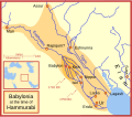
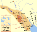
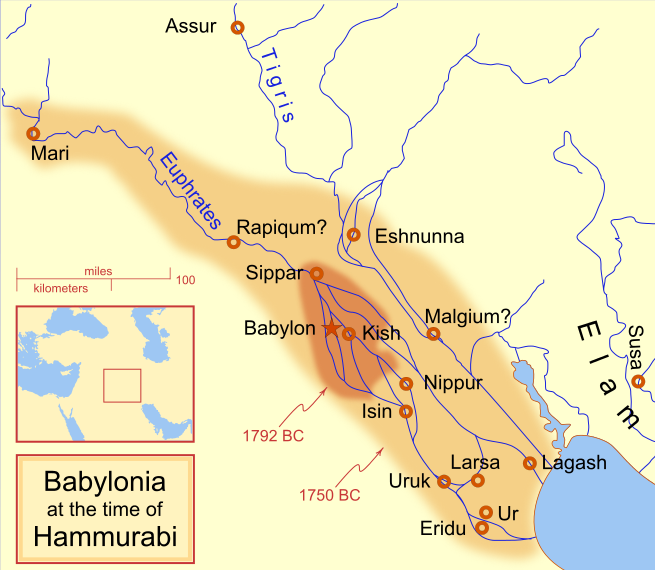
A locator map of Hammurabi's Babylonia, showing the Babylonian territory upon his ascension in 1792 BC and upon his death in 1750 BC. The river courses and coastline are those of that time period -- in general, they are not the modern rivers or coastlines. This is a Mercator projection, with north in its usual position

There is some question to what degree the cities of Nineveh, Tuttul, and Assur were under Babylonian authority. While in his introduction to his code of laws, Hammurabi claims lordship over these cities, Roaf does not include any of these in his map, upon which this map is based, and Chevalas states that "Assur and Nineveh were held for a very few years" (p. 155). Therefore, I have not included them as under Hammurabi's control in 1750 BC.
Daty
Loharano Asan'ny tena
Mpamorona azy MapMaster
Versiona hafa

[ovaina]

See also

References

  • Bjorklund, Oddvar; Holmboe, Haakon; Rohr, Anders (1970) Historical Atlas of the World, Barnes & Noble, NY, SBN: 389-00253-4.
  • Chavalas, Mark W.; K. Lawson Younger (2003) Mesopotamia and the Bible, Continuum International Publishing Group, ISBN 978-0567082312.
  • Hammond World Atlas Corporation (2007) Historical World Atlas, ISBN 9-780843-71391-6
  • Roaf, M. (1990) Cultural Atlas of Mesopotamia and the ancient Near East, Oxford: Facts on File. (In general, the basis for the ancient river courses and ancient coastline).
  • Van De Mieroop, Marc (2005). King Hammurabi of Babylon: A Biography. Blackwell Publishing. ISBN 1405126604

Navoaka tambanin'ny lisansy

Moi, en tant que détenteur des droits d’auteur sur cette œuvre, je la publie sous les licences suivantes :
GNU head Nomena ny alalana mandika, mizara ary/na manova ity rakitra ity araka ny GNU Free Documentation License na versiona hafa toariana natontan'i Free Software Foundation; tsy misy fizarana tsy azo ovaina, tsy misy soratra andoham-pejy na soratra am-param-pejy. Ao amin'ny fizarana mitondra anarana GNU Free Documentation License ny soratr'ity fahazoan-dalana ity.
w:fr:Creative Commons
mahalala ny namorona azy voalohany zaraina mitovy
This file is licensed under the Creative Commons Attribution-Share Alike 4.0 International, 3.0 Unported, 2.5 Generic, 2.0 Generic and 1.0 Generic license.
Azonao am-palalahana:
  • ny mizara – ny mandika, mizara sy manome ity vokatr'asa ity
  • ny mamerina – ny manova ity vokatr'asa ity
Raha manaraka ireo fepetra ireo :
  • mahalala ny namorona azy voalohany – Tsy maintsy manome fampahalalana arifomba momba ny mpamorona ianao, manome rohy manondro ny fahazoan'alalana ary raha nisy fiovana natao. Azonao atao amin'izay fomba rehetra azo atao izany zavatra izany, fa tsy amin'ny fomba milaza hoe manohana na manaiky ny fampiasanao an'ilay asa ilay mpamorona.
  • zaraina mitovy – Raha manova, mamadika na mifototra amin'ity asa ity ianao dia tsy maintsy mizara ny vokany amin'ny lisansa mitovy na mifandraika amin'ny lisansan'ny asa niaviana.
Afaka mifidy iray amin'ireo lisansa ireo ianao.

Légendes

Ajoutez en une ligne la description de ce que représente ce fichier
Babylonian

Éléments décrits dans ce fichier

dépeint Frantsay

Valeur sans élément de Wikidata

18 Febroary 2008

type MIME Frantsay

image/svg+xml

Tantara ny rakitra

Tsindrio eo amin'ny daty/ora iray mba hijery ny toetra n'ilay rakitra tamin'io fotoana io.

(vaovao indrindra | antitra indrindra) Hijery (10 vao haingana | ) (10 | 20 | 50 | 100 | 250 | 500).
Daty sy orasaritapakaHabeMpikambanaresaka
ankehitriny21 Aprily 2013 à 09:14Vignette ho an'ny 21 Aprily 2013 à 09:14655 × 570 (183 kio)CitypeekCleanup of file. Valid SVG now.
27 Aprily 2010 à 19:06Vignette ho an'ny 27 Aprily 2010 à 19:06655 × 570 (168 kio)DieBucheremoved border
30 Jolay 2009 à 15:05Vignette ho an'ny 30 Jolay 2009 à 15:05661 × 580 (317 kio)Amit6Some nodes changed.
3 Martsa 2008 à 23:24Vignette ho an'ny 3 Martsa 2008 à 23:24661 × 580 (163 kio)MapMasterAdded city-state, moved Sippar, minor other changes based on recent Kassite map
23 Febroary 2008 à 16:06Vignette ho an'ny 23 Febroary 2008 à 16:06661 × 580 (161 kio)MapMasterAdded 1 city, added name for 1 city
21 Febroary 2008 à 03:29Vignette ho an'ny 21 Febroary 2008 à 03:29661 × 580 (159 kio)MapMaster"blurred" the territory outlines
20 Febroary 2008 à 23:25Vignette ho an'ny 20 Febroary 2008 à 23:25661 × 580 (155 kio)MapMasterChanges made based on info from ''Mesopotamia and the Bible''
19 Febroary 2008 à 02:03Vignette ho an'ny 19 Febroary 2008 à 02:03663 × 580 (156 kio)MapMasterFixed an error on my part
18 Febroary 2008 à 21:12Vignette ho an'ny 18 Febroary 2008 à 21:12332 × 292 (156 kio)MapMastersome minor edits
18 Febroary 2008 à 19:19Vignette ho an'ny 18 Febroary 2008 à 19:19332 × 293 (154 kio)MapMasterremoved unrenderable bmp
(vaovao indrindra | antitra indrindra) Hijery (10 vao haingana | ) (10 | 20 | 50 | 100 | 250 | 500).

Mampiasa ity rakitra ity ireo pejy 3 ireo:

Fampiasan-drakitra maneran-tontolo

Mampiasa ity rakitra ity ireo wiki hafa ireo:

Hijery fampiasana eran-terikasan'ity rakitra ity.

Metadata