
Sary:Abbasid Caliphate 891-892.png

Haben'ny topi-maso: 800 × 382 teboka. Habe hafa: 320 × 153 teboka | 640 × 306 teboka | 1 024 × 490 teboka | 1 280 × 612 teboka | 3 054 × 1 460 teboka
Rakitra niaviana (3 054 × 1 460 teboka, haben'ilay rakitra : 1,44 Mio, endrika MIME : image/png)
Ambangovangony
| Visavisa |
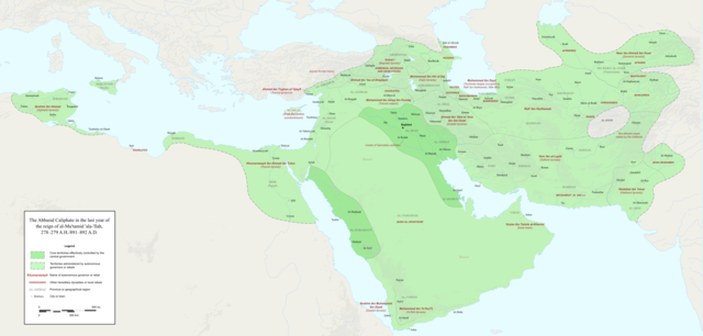
English: Map of the Abbasid Caliphate at the end of the reign of al-Mu'tamid in 891-892. Dark green denotes provinces under the effective control of the central government; light green denotes provinces under the control of autonomous governors or rebels.
The core Abbasid territories include Shahrazur, Darabadh, al-Samaghan, Hulwan, Masabadhan, Mihrijanqadhaq, the Euphrates districts, and Qarqisiyya (al-Tabari v. 37, p. 98; Bianquis p. 96). Map originally created as an .SVG file in Inkscape and converted to .PNG for size reasons. Background topography taken from DEMIS Mapserver, which are public domain. Works Cited:
|
| Daty | |
| Loharano | Asan'ny tena |
| Mpamorona azy | Ro4444 |
| Versiona hafa |
 |
Moi, en tant que détenteur des droits d’auteur sur cette œuvre, je la publie sous la licence suivante :
Ce fichier est sous la licence Creative Commons Attribution – Partage dans les Mêmes Conditions 4.0 International.
- Azonao am-palalahana:
- ny mizara – ny mandika, mizara sy manome ity vokatr'asa ity
- ny mamerina – ny manova ity vokatr'asa ity
- Raha manaraka ireo fepetra ireo :
- mahalala ny namorona azy voalohany – Tsy maintsy manome fampahalalana arifomba momba ny mpamorona ianao, manome rohy manondro ny fahazoan'alalana ary raha nisy fiovana natao. Azonao atao amin'izay fomba rehetra azo atao izany zavatra izany, fa tsy amin'ny fomba milaza hoe manohana na manaiky ny fampiasanao an'ilay asa ilay mpamorona.
- zaraina mitovy – Raha manova, mamadika na mifototra amin'ity asa ity ianao dia tsy maintsy mizara ny vokany amin'ny lisansa mitovy na mifandraika amin'ny lisansan'ny asa niaviana.
Tantara ny rakitra
Tsindrio eo amin'ny daty/ora iray mba hijery ny toetra n'ilay rakitra tamin'io fotoana io.
| Daty sy ora | saritapaka | Habe | Mpikambana | resaka | |
|---|---|---|---|---|---|
| ankehitriny | 3 Desambra 2017 à 23:18 | | 3 054 × 1 460 (1,44 Mio) | Ro4444 | Further color corrections |
| 3 Desambra 2017 à 22:50 |  | 3 054 × 1 460 (1,44 Mio) | Ro4444 | Color correction | |
| 3 Desambra 2017 à 21:11 |  | 3 054 × 1 460 (1,44 Mio) | Ro4444 | User created page with UploadWizard |
Fampiasana an'io rakitra io
Tsy misy pejy mampiasa an'ity rakitra ity.
Fampiasan-drakitra maneran-tontolo
Mampiasa ity rakitra ity ireo wiki hafa ireo:
- Fampiasana eo amin'i ar.wikipedia.org
- Fampiasana eo amin'i de.wikiversity.org
- Fampiasana eo amin'i en.wikipedia.org
- Fampiasana eo amin'i en.wikibooks.org
- Fampiasana eo amin'i et.wikipedia.org
- Fampiasana eo amin'i fa.wikipedia.org
- Fampiasana eo amin'i hy.wikipedia.org
- Fampiasana eo amin'i id.wikipedia.org
- Fampiasana eo amin'i ja.wikipedia.org
- Fampiasana eo amin'i no.wikipedia.org
- Fampiasana eo amin'i pt.wikipedia.org
- Fampiasana eo amin'i sco.wikipedia.org
- Fampiasana eo amin'i uk.wikipedia.org
- Fampiasana eo amin'i uz.wikipedia.org
- Fampiasana eo amin'i zh.wikipedia.org